Seeing as I’m stuck at home 23/7 and slowly losing my sanity due the boredom, I thought I’d put together a little photographic tour of Mile Cross using some of the old pictures from some of the previous blog entries. Walk with me on an imaginary tour of Mile Cross, just bear in mind that you’ll need to gloss over the fact that the timeline is all over the shop and that the route is a bit nonsensical. 2020 has been a nonsensical year so far anyway, so it should be easy enough to tag along.
I’ll enter the estate through Wensum Park, up Mile Cross Road and into the northern parts of the estate; back down to – and then all the way along – Drayton Road, turn back across the old Galley Hills to Bignold Road before heading south back down to the valley and towards Hellesdon along the old railway line. If we hurry through, it should take us roughly a state-sanctioned hour, but please do keep your distance…
I’ll start by entering Mile Cross from Heigham. The Wensum flows under Railway bridge 247 before curving past Wensum Park, although Wensum Park is yet to be built. The trees at the top left of the image are located between Aylsham Road and Drayton Road next to where the mini roundabout now sits by St Martins Road. In the near foreground you can see where the dyke that runs all the way from Sweetbriar enters the river, and just above that you can make out greenhouses of a nursery that was located where Aldi and Home Bargains now live. The photographer was standing on footbridge 247b that carried the Dolphin footpath over the railway line and into the estate, which in this picture hasn’t been built yet either:
If you turn right at the now relocated bridge 247b (which now gets you across the dyke/storm drain at ground level), there is a little footpath that leads you along the river and into Wensum Park, if the gate isn’t locked that is.
If the gate from the future does happen to be open, we can enter the park where the duck-pond connects to the river. Luckily in the 1930’s there were more foot-bridges to help us get around the neat-looking park:![Wensum Park lily pond with rustic bridge [B163] 1931-00-00](https://themilecrossman.files.wordpress.com/2019/03/wensum-park-lily-pond-with-rustic-bridge-b163-1931-00-00.jpg?w=788)
After finding our way into the park and taking a while to admire the duck-pond (there were no long-abandoned Ofo bikes and plastic traffic cones back in 1931), we head up the hill towards the pavilion to have a look at it being built by veterans of the Great War. It looks like hard work using only 1920’s equipment, but they were more than likely fairly happy to be getting a wage. Behind the pavilion we can just about make out Drayton Road:
A posed photo of some of the workers, on the left is Herbert Woodhouse, who was suffering with damaged lungs after being gassed during the war, sadly he didn’t live much longer because of his internal wounds:
After climbing the freshly-built steps up to the pavilion’s roof-terrace we are greeted with a good view of the park. Families sit by the fountains enjoying the park and In the background we can see right across the river and the railway, right over into to Heigham. Note the Heigham Cabinet Works and a distant Signal for Norwich City Station:![Wensum Park fountain view towards N Heigham [B164] 1931-00-00](https://themilecrossman.files.wordpress.com/2019/03/wensum-park-fountain-view-towards-n-heigham-b164-1931-00-00.jpg?w=788)
As we head back down towards the river to get a better look at the now-finished pavilion, you can see that all the hard work has paid off. Wensum Park is looking a lot more splendid than it does today. To the top right are the grand-looking houses on St Martins that had a commanding view over the park, unfortunately, these houses were destroyed by enemy action in the second world war:![Wensum Park fountain and shelter [B155] 1931-00-00](https://themilecrossman.files.wordpress.com/2019/03/wensum-park-fountain-and-shelter-b155-1931-00-00.jpg?w=788)
Ignoring Drayton Road for now we head off up Mile Cross Road towards St Catherine’s where we encounter a troop of scouts being loaded onto the back of a lorry for a trip to the coast just outside the Phoenix Centre, the parents linger on the pavement to wave their youngsters goodbye, presumably before hurrying off home to hit the wine:
As we pass by the scouts about to head off for a weekend at the coast we stumble upon their new Scouts Headquarters. The ’25th’ have recently located to Mile Cross from Duke Street after their previous headquarters were destroyed by enemy bombs. You can make out the roof of St Catherine’s Church hall (where the 25th live today) behind the bushes on the left:
Somehow, we’ve ended up on the roof; as you do when on a virtual, nonsensical walks… Mile Cross Road and Kirkpatrick Road can be seen down at ground-level, note how the verges are made from actual grass and there aren’t rusty Vauxhall Astra’s and company vans parked up all over the place: 
After climbing down from the roof of the Mile Cross Scout-hut we head off up Kirkpatrick Road to it’s junction with Oxnead Road, where we encounter Mr Leeds standing by his smart-looking car currently parked in his friend’s driveway, from where he’s he’s about to give somebody a driving lesson. Note the two scamps on a bicycle exiting the garages and heading for Kirkpatrick Road in the background:
We leave Mr Leeds to get on with his driving lessons and head deeper into the estate, this time to one of the widest and more grand roads on the estate, Suckling Avenue. This was the original ‘grand entrance’ to Mile Cross, the homes have some unique architecture and the verges lined with double-rows of trees and large verges, which would have given the road a wide, green and open feel back in the day:
From here we decide to cut through towards The Boundary and we find some of the estate’s narrower streets. Heading down Bolingbroke Road we encounter two members of the Wall family stood in the front garden of one of their recently-built Mile Cross homes. They look baffled as to why we’re in their garden with them, so we leave them in peace and make are way towards Spynke Road:
There’s a lot going on at the corner of Spynke Road and Bolingbroke Road as a WW2 USAAF bomber has crashed into the back gardens of the homes leading to a number of fatalities. Best not hang around here for too long. The houses in the background are at the Northern end of Rye Avenue and the two houses on the right side of the image run along Boundary Road: 
A bit of a jump now, we’re going to make our way all the way back down to Wensum Park again so we can walk the length of Drayton Road. The Edwards and Holmes Shoe factory ominously stands proud next to the corner of the Park, which was to be another building destroyed by enemy action during the second world war:
Get your waders on, because we’re heading across the river Wensum to get a good look at the rear of the factory:
After drying ourselves off, we make our way up Drayton Road until we come to the junctions of the handily-named Junction Road and Havers Road. Note the Dolphin Footpath sign showing you how to get back to Heigham. The old sign is still in a similar position today. 
Carrying on along Drayton Road as it heads upwards and West, we come to its busy junction with Mile Cross Road and the large parade of shops. It looks a bit safer in this image, however it was due to a number of accidents and at least one fatality that this junction was then changed to the roundabout we all know and love today: 
A little further up the hill and at the junction with Wheeler Road we come across this fantastic scene from 1929. The steam-powered road maintenance vehicles belong to the Norwich Corporation and they’re here to re-lay the road surface. There’s a speed camera here now, but I don’t think they’re in any danger of setting it off:
If we look the other way and further up Drayton Road, we can see that it climbs towards the Galley Hills. The terrain here becomes quite undulating. There’s a brick surface shelter on the other side of the road which means this picture was taken during or just after the second world war, the youngsters riding two abreast on their bicycles would be on the receiving end of a torrent of abuse (most likely from a man in a van) if they were to pull that trick today:
As we go over the crest at Parr and Bignold roads, the road heads down the lower slopes of Galley Hill, where we find the Galley Hill Pub. I wonder how it got its name:
Seeing as we’ve been walking for some time now, it’d be rude not to pop in for a ‘swift half’; however, the landlord (Alfred Ernest Bailey) looks less than impressed at his time-travelling customers. “Shouldn’t you lot be self-isolating?”:
Taking heed of his advice, we head back out of the main entrance and through the ghosts of the future landlord of the past; Frederick and Florence Coultas watching us leave as we continue our journey along Drayton Road towards the city’s edge:
As we reach the bottom of the hill, we are greeted with the ‘slough’ a geological low-point where – unless we head into Sloughbottom Park – we have to head uphill. To our right and messing around in the corn-field on the side of the ridge we can see the young Stuart Ulph. From here we can look down onto Drayton Road across what was once “Wade’s” and part of the Whiffler Industrial Estate, Drayton Road heads up and out of the slough towards Asda:
As we reach the top of Drayton Road we find Stuart’s farther stood near the roundabout where the Boundary, Sweetbriar and Drayton Roads meet up. Asda hasn’t been built for another 30 years and the roundabout looks about as busy then as it does in the current climate. We can see the back of the “Welcome to Norwich, A Fine City” signage board:  We now follow Stuart’s dad as he makes his way back towards the estate, cutting directly across the heathland that is occupied by Busseys towards Bowers Avenue, skimming the boundary of old ‘Fungi’ (Farmer Prentice)’s land towards the Galley Pirate’s Cycle Speedway track that now lives underneath the 1960’s extension to the Estate:
From here we can see the back gardens of the Houses at the top end of Bignold Road, spotting a gap in one of the fences we take a shortcut through the Sheldon family’s garden at number 2, luckily they’re pre-occupied with a dog and a camera and we slip through and out on to Bignold Road:
As we head back down Bignold Road towards the Drayton Estate we encounter the Bayes family in their front garden of their home on the corner of Bignold Road and Gresham Road. Ethel eyes us suspiciously: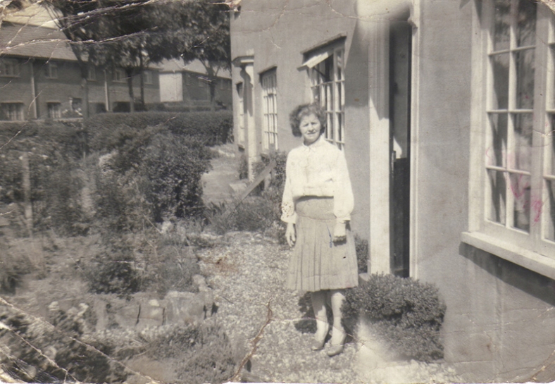
Putting on her coat to show us out of her garden. Note the sign for Gresham Road behind her and the now long-demolished concrete block houses that made up a large part of Bignold Road:
We leave Ethel’s garden via the driveway to carry on our journey and it looks as though she’s glad to get rid of us:
We cross Drayton Road at the bottom of Bignold Road, make our way down down Parr and towards Valpy Avenue. From here we take one last look at the old estate, being watched by the tiny figure of Mary Jacobs as we pass her house on our way down to the railway line. Mary’s house would have had a good view of the old M&GN line right up until the Vale Green development turned up to ruin the view:

We hop over the side of the Mile Cross road bridge and down onto the railway line that will lead us back out of the estate, mind your backs though as the ghosts of locomotives are still very much active along here:
As we make our way along towards Sweetbriar Road, another locomotive, a Diesel this time, is heading towards us so we’d better clamber up the bank and on to the bridge to watch it clatter on by. It’s about to head past the back of Sloughbottom Park and through part of the Mile Cross Middle School ‘Cross Country’ running course as it makes its way into City Station:
We’ve properly left Mile Cross now, crossing another of the distinctive ‘A-Frame’ bridges that brought these rails into Norwich over the winding Wensum, and it’s time to take one last look back towards Mile Cross before we all head off on our separate ways. We’d better split up now or we might run the risk of having our collars felt by the local constabulary for being outside (whilst being inside) in a group, through the ages (see, I told you it wasn’t going to make too much sense!):
And there ends our rather complicated and nonsensical walk about the old estate, I hope you all managed to keep up and that you enjoyed all the old pictures and little bit of history along the way.
Thanks for reading this stuff, and stay safe.
Stu

Thanks Stuart, I enjoyed the virtual tour before heading out for my daily exercise to enjoy the real thing on this lovely morning. Happy Easter
LikeLiked by 1 person
Brilliant Stuart
LikeLiked by 1 person
Excellent as ever., Stuart….wonderful memories of times past, even for we incomers.
LikeLiked by 1 person
Thanks for putting that together, I really enjoyed it!
LikeLiked by 1 person
Excellent, have you any photos of the old Galley Pirates Cycle Speedway track?
LikeLiked by 1 person
Only the replacement in Sloughbottom park
LikeLike
Amazing. Loved it all. I grew up on Rye Avenue, 2 separate houses, and the plane crash was at the top of my garden (94) I was told! Great to see the picture of Fred Leeds, I went out with his daughter Jane for a while before she moved to the USA. Congratulations mate. Steve Hague.
LikeLiked by 1 person
Thanks Stuart. A lovely gift for Easter Day to see my dear old Dad with a big smile on. I hope you’re well and continue to stay that way.
LikeLiked by 1 person
Thanks Stu, for the memories, especially our dear old dad and to see a fellow mile cross occupant, Steve Hague on the replies. I was speaking to my sister Jane this evening and will pass your blog in Washington, USA
LikeLiked by 1 person
Thanks Susan, he did look like he had an infectious smile 🙂
LikeLike
Brilliant Stuart – and some choices pictures for use in all sorts of things. Keeping the flame alive for the big return!
LikeLiked by 1 person
Fascinating piece, Stu, and put together superbly in both word and image (as is equally the case with your other blog posts). Though a south Norwich boy now exiled in Pennsylvania, I know my city well and can relate to many of the locations mentioned. For instance, Mile Cross Road was my cycle route home from the speedway.
LikeLiked by 1 person
That was interesting Stu, enjoyed it immensely. Do you have any history of Woodward road? I live at no 15, it’s bathroom is enclosed with no windows, I understand it was rebuilt after a bombing Luftwaffe raid put a large hole in the back! I’d like to know more about it if you can..
Thanks again
Bruce.
LikeLike
By the looks of it, there were a few bombs to fall along Oxnead Road, which your home must back onto. Probably blast damage.
LikeLike
Hi Stu, this was a fantastic read, I’ve just stumbled across your blog while searching for a bit more info about Norwich. Do you happen to know what year the Bolingbroke Road/Wall Family picture is from? I happen to know them very well and we’re all amazed at this picture and trying to figure out the year. Thanks!
LikeLike
Hi Liam, thanks for the feedback. The image was taken in 1929 and was given to me by Dennis. I wrote a piece about it here:
https://wp.me/p8D5e1-NJ
LikeLike
stuart ulph in one of the pictures lived on bowers close he is a few years older than me but i remember living next to him . the family moved when i was about 8 so it must have been about 1970 . would love to see some pictures of tne old galley pirates cycle speedway track . i remember watching the racing there near to where the shops are now .
LikeLiked by 1 person
Loves reading this again…. yes in read it again after reading it last year I grew up ok bignold road my parents still live there I love the history of the estate… I also cared for a lady called Betty she lived on bignold road and she always used to tell me how the little boys would nick the apple of her trees on their way home from school she was a disabled lady but went on to teach swimming and was well known in the community she passed away about 5 years ago now I think her surname was Gooch
LikeLiked by 1 person
Also I remember the people still having the outside toilets in 90’s it would be freezing 🥶 in the winter
LikeLiked by 1 person