Retail Therapy.

Built in 1928 this parade of shops was built either side of Mile Cross Road at its cross roads with Drayton Road to serve the locals with all their retail needs Continue reading “Retail therapy”
Retail Therapy.
Built in 1928 this parade of shops was built either side of Mile Cross Road at its cross roads with Drayton Road to serve the locals with all their retail needs Continue reading “Retail therapy”
I must admit that I’ve talked quite a lot about Drayton Road in this blog, mainly because it has a lot of stories to tell and partly because I’ve lived on (or just off) it for all bar seven years of my life. This is the main artery for traffic in and out of the City from the North-West and effectively chops about a third of the estate off along the southern portion. Located in the Island part of the estate from the estate’s creation and up until about ten years ago sat the majority of the estate’s schools (Dowson First and Mile Cross Middle), so getting the kids across Drayton road safely required a lot of work from the two sets of dedicated Lollipop ladies.
The first set operated at the crossroads of the Drayton, Bignold and Parr Roads and the second set a few hundred meters down the road at the (long-since closed) junction of Drayton and Wheeler Road. In the early to mid 1980’s, both sets of ladies witnessed their fair share of drama and tragedy.
Two incidents stand out amongst the madness that was – and still is – getting across Drayton Road as a child and I’ll start with the later incident first:
In the mid-1980’s a driver claiming to be unsighted by the low morning sun as he came up Drayton Road from North West ploughed straight through a crowd of Mile Cross Middle and Dowson School children being shepherded across the road by the crossing lady. How nobody was killed is beyond me; one boy ended up near the bus stop, the boy walking just in front of me was thrown 20 feet into the air…. blood, chunks of hair, scattered books and Panini stickers littered the scene.
The result was this pelican crossing, installed slightly east of the junction:  Continue reading “Nigel Neale”
Then and now. Mary Jacobs.

Mary Jacobs poses proudly for a photograph Continue reading “A window into the past”
Not one of my normal, long and rambling posts today, and not a single photograph will be harmed in the process:
One of the biggest bugbears I have about living in Mile Cross is the seeming apathy from some of the other residents towards issues that can make parts of the area appear scruffy Continue reading “Fix my street”
Straying away from the estate for a bit, I’m going to be talking about how the digital world can bring people together in the real world.
Since being knee-high to a grass hopper I’ve been fascinated by a stretch of path that runs along the back of Sloughbottom Park. It starts at the inner-link road by Halfords and makes its way along the Wensum Valley all the way to Themelthorpe, before curving East towards Reepham. You’ve probably heard of it as it’s called: ‘The Marriott’s Way’; but before it got ‘all official’ it was just an overgrown and dusty old path where a railway used to run. Back then it was mostly impassable in Summer and littered with the wrecks of stolen and burnt out cars and bikes.
I first encountered the path as a child. My Auntie used to live in Costessey in a house somewhere near Leewood Crescent (I can’t remember exactly where) and later, my Nan lived in a Bungalow at the bottom of Oval Road. Back in those days my family did a lot of walking, and the most direct route to go and visit these nearby family members would have been through Sloughbottom Park and down the old railway line. The path wasn’t metaled back then as it wasn’t officially a path, so it was often full of nettles or damp and muddy. Or both. I remember in the height of Summer having to fight our way through the nettles with a stick. Even so it was quicker to go this way rather than follow the roads. I’d be back and forth along here on a regular basis and the path became well and truly etched into my memories.
One day my mum stopped at a stretch of brick wall that I’d never noticed before – even though I must have walked past it countless times (It must have been exposed from the weeds because of winter die-back) – to give me an impromptu history lesson. She told me that it used to be the site of an old railway station called Hellesdon that had been closed back in the 1960’s. She had vague recollections of it even though it had shut to passengers back in 1952. The station still served Norfolk County Council as a storage spot for road aggregates. The station building being used for other things, such as a Sunday School and later as the headquarters for a company named: ‘Anglian Culinary Services’.
The building eventually fell into disrepair and was used as a drinking hotspot for youths from the nearby Marlpit Housing Estate. To resolve this problem the council decided to knock the building down. Unfortunately this turned out to be a rather a short-sighted solution. Along with the Station house about a third of the platform was also destroyed, and then weirdly finished off neatly with some later, red brick.  Continue reading “FONCS: Friends of Norwich City Station”
Mile Cross and it’s surroundings is – or was – home to a number of pubs, 10 in total; most of which existed before the creation of the estate.
Two of these pubs however, were created along with the estate and in my eyes that makes them the ‘proper’ Mile Cross pubs.
Seeing as it’s closer to home, I’ll start with the Galley Hills:
 Continue reading “Pubs pubs pubs.”
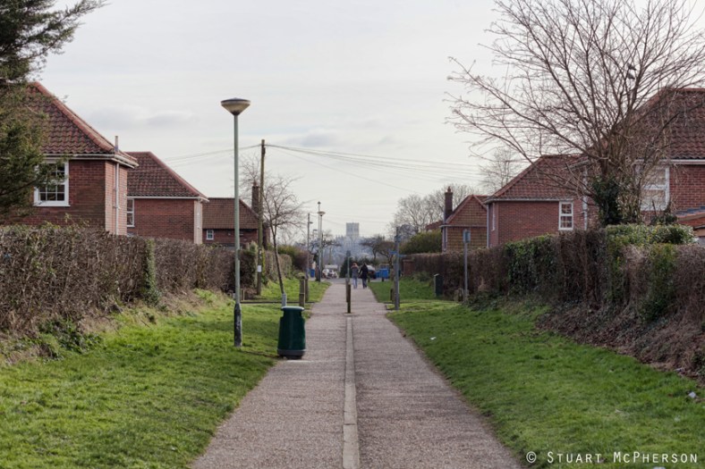
Sight lines: something sadly lacking from any of the later additions to the estate, and something seemingly lacking from anything else designed in Norwich from the 1960’s onwards.
This shot is taken looking South along the long footpath simply named: ‘The Lane’ by the estate’s engineers.