The other evening I did something I rarely get the chance to do these days and that was to sit in my ‘old man’ armchair with my two cats curled up on my lap and watch a bit of telly. As I scanned the Virgin box to see what I’d been recording, I found a fairly new series going by the name of the ‘Bone Detectives’ which looks into the history of people and their surroundings by analysing their bones.
The episode I had decided to watch was looking into the past of the remains of three young bodies (a male child and two young teenage girls), unearthed in Leeds whilst clearing a site to build a posh-knobby shopping centre. As it turned out, these poor little souls were victims of the Industrial revolution and had literally been worked to death, with all the evidence pointing to the likelihood that they would have been working from dawn until night in a nearby cotton mill.
The area around the mills in which they lived was made up of hundreds of tiny, back-to-back, ‘one-up, one-down’ terraced houses lined up in a rather uniform-looking fashion with no real outside space or much natural light. Watching the presenters looking at the neat rows of squares on their old map of Leeds got me thinking: Did Norwich have any houses similar to these? I’m very familiar with old maps of Norwich and couldn’t recall seeing anything that looked like this particular style of housing, so I made a mental note to look into it later.
When the show had ended and with the cats still lazing on my lap I decided that there was no time like the present to start my search. The best (and free to use) detailed maps I have access to only date back to the late 1800’s, anything before that and there isn’t enough detail to be able to accurately discern what types of buildings you’re looking at unless they’re large or important enough to have their description written down. Thankfully, these later Victorian Maps, particularly the 1:500 Ordnance Survey Town Plans of 1880’s, are in my opinion still some of the best ever produced for detail.
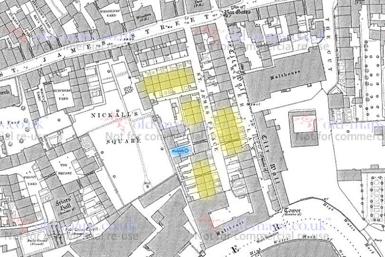
As I scanned the maps of Norwich looking for this very particular style of house I decided to head to the areas where I thought they’d most likely be; in or around the dense yards of St Augustine’s, Oak Street, St Martin’s and many more throughout Norwich over the Water. As I pored over the maps I found a plenty of back to back houses in the higgledy-piggledy yards but nothing immediately as obvious as those neat rows of uniform houses I’d seen on the telly. Unperturbed I continued searching, following the course of the River Wensum as it snaked its way through the City Centre until my eyes fell upon a small collection of houses, just north of the Wensum and tucked inside the remains of City Wall as it made its way down to the bank opposite Silver Road. This little side street was named: St James Palace.
©www.old-maps.co.uk
These neatly-arranged houses were the closest thing that I could find to what had triggered my curiosity in the first place, only on a much-smaller scale. However, there were a few subtle differences, most looking like they had smallish front gardens and one of the neighbouring houses even appearing to have a fountain in the back garden. This fountain must have been significant enough for the Victorian cartographer to note it on their map. Although these homes weren’t located in the finest quarter of Norwich by a long-shot, it was hardly comparable to the acres and acres of squalid, cramped little homes housing thousands of people in Industrial Leeds being depicted by the programme on the TV.
I conceded that a lot had changed between the early 1800’s to the later 1800’s, particularly here in Norwich, especially when you take into account the large-scale replacement of terraced housing in and around the 1860’s. I then told myself that this particular subject was something I wasn’t really going to scratch the surface of, not without putting in a whole load of time and effort. So with my initial curiosities mostly satisfied, my somewhat seemingly-pointless search was done. Well, that’s what I’d convinced myself of for all of about 30 seconds…
As often happens to me when I start scratching the surface of something seemingly-insignificant to me historically or map-related, this curious little mind of mine began to wonder. Why were these houses here? Who lived in them? Were there any traces of the past still remaining for me to look into? What was St James Palace? Obviously my initial curiosity was far from satisfied and it had only left me with more questions, so I decided to carry on digging. When I say ‘digging’ what I actually mean is have a bit more of a “Google” whilst still sitting in my old-man armchair trying not to disturb the still-snoozing cats who were awkwardly taking up what real-estate there was on my lap.
The neatly laid out homes that had captured my attention from above on the map were located on either side of a short street named: ‘St James Palace’ as it ran south from a junction with what was then ‘St James Street’ (now an extension to Barrack Street); however, in reality this was more of a dead-ended Yard than a street, and unlike most of the traditional yards which were usually accessed through a tiny and often-covered little alleyway between other street-fronting buildings, this one had a fairly large entrance – large enough for traffic and carts at least – and this fairly neat-looking yard (from above at least) led down to a Malthouse situated on the northern bank of the Wensum and behind St James Mill (now Jarrolds).
These homes were obviously built to house the workers for one of the many industries going on nearby in this tightly-packed quarter, their arrangement being somewhat more organised than the more densely-packed and confusing arrangements of their more traditional neighbouring yards, leading me to suspect that these particular homes would have been built by one of those Industries, and going by their date I would hazard a guess that they were either built to accompany the nearby St James Silk Mill, which would tie in very nicely with what had triggered my curiosity with it all in the first place, or built for the Malthouse that formed part of the Yard.
However it came to be, St James Palace Street was more commonly referred to as ‘Palace Yard’ and in its later years was deemed to be connected with some of the worst slum areas in Norwich, particularly the complex maze of yards on either side of it. Like most of the other countless Yards dotted around Norwich, this one managed to survive right up until the 1930’s before it finally succumbed to the on-going, city-wide slum clearances.
The courts and yards of Norwich were notorious for their squalor, particularly in the Victorian era, but between the start of the century and the 1930’s the yards would have had some significant improvements made, making them a fair bit nicer than they were before WW1, however, they were still deemed as being particularly unsanitary. In reality they weren’t necessarily much worse than some of the other working class properties across Norwich that weren’t labelled as “yards” particularly the countless rows of terraces throughout Lakenham and what we now call the “Golden Triangle”. What set the yards aside from the rest of the inadequate terraces throughout the city was the fact that they were suffering with some unique issues that made them a higher priority for clearance, mainly being their inadequate water supplies, scant amounts of daylight and poor ventilation.
Public health statistics also pointed to the fact that the yards along Barrack Street did have higher percentages of cases of diseases and infant mortality rates than anywhere else in the city, but only just, so there was some proof to the pudding. That said, not everybody was in a hurry to move out of these yards. Tenants feared that newer, better properties would cost far more to rent out than their current (and affordable) accommodation. Also adding to the anxiety of moving out was the fact that a lot of the new housing estates emerging as a response to these slum clearances were being built out in the suburbs of Norwich, meaning they were further away from the mostly city-centre-based Industry where these people were making their living.
Probably more important than their financial and geographical worries, the families living in these yards and alleys also had a strong sense of pride and community, love it or hate it, these were their homes and it was their identity. A feeling of being was never going to be enough to stop the wide-scale demolition of homes and the council quickly set about registering hundreds of these properties as unfit for human habitation. In the end these inhabitants had little choice and their communities were eventually relocated, mostly out to one of the new housing estates appearing on the outskirts of the City or across to one of the nearby tenement-style flats popping up close to where their old yards had been recently flattened.
Still in my cats-on-lap limited ‘research’ mode, I headed down to Barrack Street on Google maps to see if there was anything obvious still in situ. To my surprise the entrance to St James Palace Yard (Palace Yard) was actually still there, along with about a third of the old, cobbled road leading into the former yard and heading south towards the river. Not only was a large portion of Palace Yard’s footprint still visible, some of the original nearby one-up, one-down dwellings had survived and were still standing by the entrance to the yard on Barrack Street.
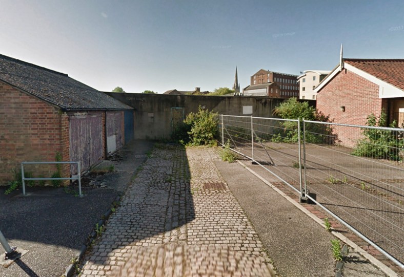 Palace Yard road surface (Google maps).
It’s funny how these little things can make random connections in the brain but it appears that these old houses have been on the periphery of my conscious for some time now, almost triggering my interest as I drive past on my way to the dentist or St James Hill, yet not quite getting through the historical noise-filter in my oh-so cluttered brain. Until now that is. I then remembered that back in 2010 the newer buildings sandwiched in between these older yard-connected homes used to be home to the RSPCA’s: ‘Paws centre’, which is where I picked my two, then-young rescue cats, still curled up on my lap, one of which (Boycie) was now snoring.
Somehow, the older homes located either side of the former RSPCA building (numbers 69, 71, 77 and 79) had managed to survive the almost two centuries of constant change going on around them. The massive Printing works came and went behind them, the nearby slums were cleared, replaced and cleared once again, and the inner-link had also arrived on the scene, completely changing the nearby landscape. Yet here was a tiny, fascinating, and somewhat plucky little pocket of early 1800’s history sitting in plain view and right under my nose.
Once again, my subconscious began piping up – somewhat inaudibly – trying to tell me that construction work had either started or was about to start where these ramshackle old houses were defiantly still standing, seemingly trying to ignoring their constantly-changing surroundings. I decided that on the next available day I’d better take a drive down there to have a little nosey, to see if there was anything worth taking pictures of just in case it was about to be cleared away, this time for good.
The following Saturday I finally got the chance to head down to Barrack Street and it appeared that my subconscious had not been wrong. As I approached the site from the Puppet Theatre (St James Church) I could now see daylight coming through from where I’d never seen daylight before. Between the row of old houses and the former-Church stood the remnants of the mostly-demolished, later-added extension to the old print works. One of its tall, outer walls had been left standing, presumably as a handy barrier to keep people out. This tall wall was now mostly-demolished and through it I could now see construction vehicles and machinery. Was I too late?
As I got nearer to the entrance to the former yard I was relieved to see that the old terraced houses were still standing but as I drove past I noticed that the old, cobbled road surface of the former yard’s footprint had been very recently covered over with fresh, black tarmac and that a new metal entrance gate to the construction site had been erected across it. Nevertheless, I parked up and managed to take a couple of shots before heading back home to continue my meandering ‘research’.
 77 and 79 Barrack Street as they are now
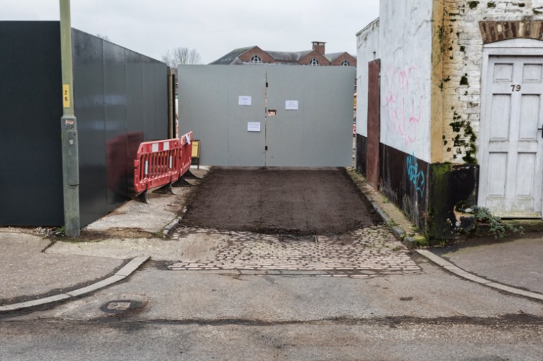 The entrance to Palace Yard from Barrack Street, now mostly hidden.
As I continued my research, looking into the origins of Palace Yard (St James Palace Street) I stumbled upon an old Derek James EDP article from 2015, written about a couple of former Flint-knappers named Robert and Elizabeth Frewer, who had lived in Palace Yard with their young son, William. The need for skilled flint-knappers had declined meaning they were forced to move from their Plaistow home in search of new work. The couple finally settled here in Norwich, finding work in the booming shoe industry of the late Victorian period.
Although their Palace Yard home wasn’t exactly the height of luxury, they were living in one of the yard’s slightly larger houses nestled in between the smaller back-to-back homes I’ve been referring to throughout this piece, and this little bit of extra space afforded them a small, enclosed garden. It was this garden that had caught the interest of Derek, and now myself, and there were two particular things about this article that really caught my attention:
Firstly, Robert had converted his small outside space into an ornate, decorative garden, complete with a fountain which was intriguingly made out of thousands and thousands of shells. So interesting was this little gem of a garden, hidden out of view in a corner of one of the city’s worst slums that it was attracting visitors from far and wide. Which also explained why (as I mentioned earlier) the cartographer had made such a point of adding it to his 1885 OS map.
The second thing about the article to catch my attention was the fact that the Frewer family would eventually have move out of Palace Yard when their home was declared to be unfit as part of the 1930’s slum clearances. From here they appeared to have been moved to one of the newer suburbs; Mile Cross. Fantastic. My research had brought out something fairly relevant to this blog.
I’ll talk about the garden first, which must have been raising income as well as interest as there was at least one photograph of the Frewers posing in their unique little garden:

The Shell Garden ©Jenny Sumser-Lupson (Grandaughter of young William).
Looking at the picture, you can see how the ‘Shell Garden’ or ‘The Fountain’ got it’s name as there are literally thousands of neatly arranged shells making up the fountain, it’s semi-circular surrounds and the decorative edges of this fascinatingly peculiar little garden. I can’t imagine that the Frewers had the means to make regular trips to the seaside, so all of these shells would have had to been sourced locally. Derek James touched upon this in his article when coming to the obvious conclusion that they must have been sourced from one of the nearby fish merchants on Barrack Street, probably from George Ramsey. To add to this, I think they may have also been sourced from one of his nearest neighbours, my later research showing that one of those surviving houses, number 79, has for a long time been connected with the business of preparing and selling fish. In the early 20th century I found that the property was owned by a Samuel Burrage who was registered as a fish merchant who had converted the home into a business, probably adding the extension to the back of the small house in the process. The Burrage name and their connection with fish continued operating from this address until fairly recently when it was running as F.W Burrage’s fish and chip shop. Perhaps, being Robert’s immediate neighbours, the Burrages were a more likely source for the thousands of shells needed to create his ornamental masterpiece.
Unfortunately this unique and beautifully-arranged little garden-attraction wasn’t to last for much longer and in 1912 the whole lot was washed away when the Wensum had rather destructively (and fatally) broken it’s banks. The shells and the fountain making a vain attempt at returning downstream towards the sea from whence they came, in a somewhat tragically-poetic fashion.
On to the second part of Derek’s article that had captured my interest, The Frewers and their relocation to Mile Cross; I had managed to find The Frewer family name (as the son, George) registered in 1926 as living at 20 Palace Yard up until the mid 1930’s and it appears that in the final few years of the yard the family had also taken over number 18. By 1935 the family name disappeared from the records, which ties it in perfectly with the Barrack Street Slum clearance programme and their subsequent relocation to Mile Cross.
Derek’s article didn’t say exactly where in Mile Cross the Frewers had moved to, so being the curious fellow I am I made it my duty to find out where they went. Thankfully, the Frewer name is quite unique which made it fairly easy to find them appearing on the records again in 1937. This time their address being number 3 Half Mile Close. Bingo.
2023 update, thanks to Jenny Sumser-Lupson, he great great grand daughter of Robert & Elizabeth Frewer, who got in touch after reading this piece recently:
“William & his wife Sarah (my great grandparents) had 3 sons & 3 daughters & other than being born in London, lived in Norwich all his life. After moving from ‘The Palace’ they went to Burgess Road then Lavengro Road & when
William passed away in 1951, Sarah moved in with her daughter in Thorpe until she passed away in 1953.
At one time, William & his son George (my grandfather – born 1898 – 4th child, youngest son) lived in adjoining houses at ‘The Palace’.
George also lived in Norwich all his life & he & his wife Alice had 7 daughters . My Mum (Joan born 1929 – 3rd child) was the last to be born at ‘The Palace’ before they were moved out to 3, Half Mile Close. They had several house moves after this – Half Mile Road (Aylsham Road end), then 35, Half Mile Road, Fenn Crescent, Theobald Road, Angel Road & finally moved in with their daughter where both passed away – Alice in 1982 & George in 1988.”
It seemed fairly obvious to me that the Frewers had moved in here in around 1935 and they were most likely the first tenants. Their new, modern house, which from it’s elevated position near the top of the northern slopes of the Wensum Valley surrounded by open and green spaces, must have seemed like a million miles away from their former yard dwellings, hemmed-in to the bottom of that very valley by Industry and all-too-close to the river that had claimed their unique little shell garden.
The Frewers’ (William and Sarah) new home was situated on the later-built ‘Mill Hill’ part of the ever-expanding Mile Cross Estate which was built on top of what used to be allotments stretching from Mile Cross Road to Junction Road and on top of the older ‘Half Mile Lane’ (which ran from the top of Mile Cross Road and down to opposite old Farm Lane.
As it turns out, I discovered that the later-added Mill Hill Estate was built specifically for people being moved out of their yards and my research teaching me something about the Mile Cross Estate that had almost completely flown over my head. Every day is a school day it seems.
The first wave of houses of the estate built throughout the 1920’s were built to such a high standard that the council put fairly high rents on them, meaning that majority of these homes were often too expensive to rent out by the type of family who would have been struggling to get by and living in one of those old courts and yards. This is why the first wave of Mile Cross tenants, mostly seemed to have well-paid jobs; almost middle-class even, which I touched upon in this older blog entry. Thankfully, this was picked up upon by the authorities and the laws and regulations were quickly updated to have this issue rectified, leading to the building of more housing, such as here where the Frewers moved in to on one of newer parts of the Mile Cross Estate.
The homes making up the Mill Hill extension to the estate were built to a slightly-lesser standard than the original wave of Mile Cross homes, making them cheaper to build and therefor more affordable to rent out. Not that these newer homes were poorly-built, far from it; they would have been built to a far higher standard than anything these former residents of the yards would have been used to. Each house having it’s own toilet, bathroom, supply of fresh water and generous gardens.
By 1947 it appears that the Frewer family had then moved again but not very far, this time they appear on the records as living just around the corner and on to Half Mile Road and only a few doors down from where I spent a year of my life living. The last mention of Frewer family I could find in the records I was looking into was in 1960 when they had moved again, but only down to Fenn Crescent, off Drayton Road. It seems that once this family had taken root in the estate they didn’t need to move very far again, all three houses in which they were registered as living in were only a stones-throw away from one another and all situated on the 1930’s expansion to the estate.
When, as I mentioned at the start of this story, that I’d sat down in my armchair to veg-out in front of the telly with my two cats curled up on my lap and to give my old brain-box a bit of rest, I hadn’t expected to be taken on a historical journey from Leeds, down to Brandon, across East Anglia, down an old yard that no longer exists in a cluttered, industrial quarter of Norwich, before ending up back here slap-bang in the middle of the Mile Cross Estate. I also hadn’t expected my two feline friends to have a tenuous connection to it all either. It’s funny what you can uncover when you start digging into something seemingly-irrelevant, and it shows you how fascinatingly inter-connected all these little stories can end up being.
What of the those houses still standing on Barrack Street that my map-scrolling had highlighted to me way back at the start of my ramblings in this piece? I couldn’t not look into why they were still standing. It turns out that they are rare examples of surviving ‘one-up, one-down’ terraced houses from the early 1800’s. This is why I couldn’t find many of them – even on the old Victorian maps – as there probably hadn’t been too many of them built here in Norwich. Even if they had, they’d mostly likely been replaced throughout the city during the 1860’s with larger terraces complete with rear access and back yards. According to the Norfolk Heritage Explorer, both 77 and 79 Barrack Street contain rare, original fireplaces and one of them has a unique “cast iron hob-grate within a timber surround” so I’ll hazard a guess at them being listed as protected in one way or another (Edit – listed Grade 2). What the developers aim to do with them and how they’ll be incorporated into the next generation of housing and industry about to be built up around them once again I simply don’t know for sure, so I’ll be paying a bit more attention to them now that they’re now well and truly on my radar and locked into my conscious.
Thanks once again for reading,
Stu

Thank you for a really fascinating blog. I hope the Barrack Street houses remain and are preserved.
LikeLike
Thanks Sue 🙂
LikeLike
Great piece again Stu. Used to buy our Fish and Chips from Burrage’s and parked on that old cobbled piece of road. Little did I know why it was there so thanks for solving the mystery!
LikeLiked by 1 person
The reason you could not find any more Frewers was William only had daughters.My son in-laws is his Grandson he has lots of Grandchildren Great and GreatGreatGrandchildren.
LikeLiked by 1 person
As my mum mentioned in a previous comment, the Frewer name has now died out. His last home in Norwich was on Angel Road opposite Waterloo Park but he lived his final days, near to where his parents had moved from in Brandon, at his daughter’s house in Thetford
LikeLiked by 1 person
IIRC there are still a couple of back-to-backs at the top of City Road, near the dairy. Converted now of course. I was told they were the last in the city.
LikeLiked by 1 person
Burrage’s fish and chips were easily the best in Norwich ! The fish would sit on plates, having been prepared in the fishmonger part of the business next door. You would pick which bit you liked and it would be fried for you. Also, I remember the cooking range as being something out of the 1920s ( it looked beautiful and unique, quite art deco and lime green coloured . The chips were cooked to perfection and the portions were generous. No frills and it was what it was….and I miss it a lot !!!
LikeLiked by 1 person
I think the range is still in there.
LikeLike
Hi, I’ve only just come across this while doing research for a family history book — I’m the great-granddaughter of Frederick Burrage. My grandfather A. Dye then ran the chippie. I remember sitting by the fireplace with my homework and a bag of chips while granddad and mum was serving people after the Lord Mayor’s procession! 🙂
Unfortunately, the building fell under someone else’s ownership. It’s really a shame that the council hasn’t seen how important the original building is and converted it to a museum or something similar.
I still have a lot of research buried in boxes as I moved to the Norfolk coast, but I believe the two buildings used to be a sweet and fish shop, until they were joined together and turned into a fish and chip shop.
LikeLiked by 1 person
Thanks for getting in touch. I bet there’s a lot of fascinating stuff hidden in your research boxes!
LikeLike
I am the great great grand daughter of Robert & Elizabeth Frewer & originally supplied the shell garden photograph to Francis & Michael Holmes for the 2nd print of their book The Old Courts & Yards of Norwich. Your research was really interesting & me told a lot more about ‘The Palace’ as it was called by my family.
I would like to correct some & supply more of the Frewer family details for you.
Robert & Elizabeth moved to Plaistow where their son William was born in 1868 but not long after returned to this area & moved into St James Palace. I would think, looking at William, that the photograph was taken in the early 1870’s. William & his wife Sarah (my great grandparents) had 3 sons & 3 daughters & other than being born in London, lived in Norwich all his life. After moving from ‘The Palace’ they went to Burgess Road then Lavengro Road & when William passed away in 1951, Sarah moved in with her daughter in Thorpe until she passed away in 1953.
At one time, William & his son George (my grandfather – born 1898 – 4th child, youngest son) lived in adjoining houses at ‘The Palace’. George also lived in Norwich all his life & he & his wife Alice had 7 daughters . My Mum (Joan born 1929 – 3rd child) was the last to be born at ‘The Palace’ before they were moved out to 3 , Half Mile Close. They had several house moves after this – Half Mile Road (Aylsham Road end), then 35, Half Mile Road, Fenn Crescent, Theobald Road , Angel Road & finally moved in with their daughter where both passed away – Alice in 1982 & George in 1988.
Far from the name dying out there is still a Mr Frewer living in Norwich & another living West of Norwich who tells me that he has done a lot of family research.
I hope this settles more of your curiosity about the Frewers & thankyou for a very interesting & informative read.
Jenny
LikeLiked by 1 person
Hi Jenny, thanks for getting in touch, and thanks for filling in some of the gaps. I have since updated the post with the extra information supplied.
Kind regards,
Stu
LikeLike