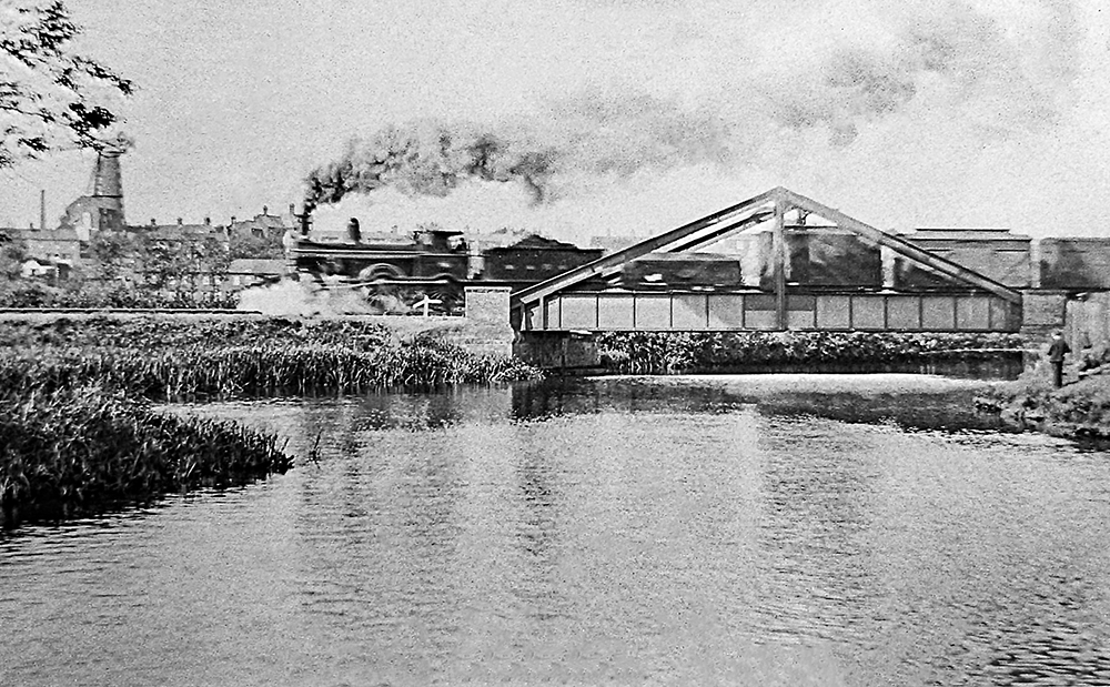
I have told the tale of the Wensum Dipper in the past, but that piece was written a while back now, and since then some new details and images have come to light in a massive collection of images and information about the history of Norwich, kindly given to me by another Mile Cross Resident, which has helped to shed some more light on this peculiar episode. For those of you who didn’t read the original piece, written way back in 2018 (have I really been running on for that long now? Mad), the story was fairly straight forward: A mix up with a set of points at the exit of the railway yard at City Station meant that a locomotive pulling a long train ended up in the murky waters of the Wensum. I managed to fill in some of the gaps with some living recollections, a bit of local knowledge, including some fine research by my good friend and fellow Mile Cross lad (and one of our Norfolk Railway Heritage Group experts) John Batley, and a little bit of educated guesswork. Now knowing more detail, it seems that we had got some of the finer details spot-on with some of our educated guesses, which is always comforting to know.
Not long after Mile Cross had completed it’s first and second waves of house-building and providing this new housing estate with over 8,000 people, it was decided (by the Bishop of Norwich) that all of these new residents needed a bit more god in their lives. God would be shoe-horned into the new estate via the medium of a shiny, new church situated right on our doorsteps. The building of a new church is by no means a cheap venture so it was decided (once again by the bishop of Norwich) that a fundraising appeal for this new church would be sent out with haste.
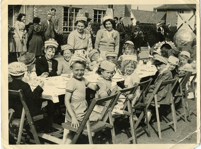
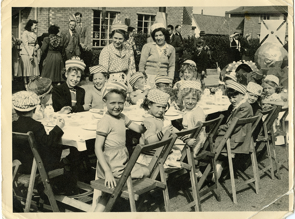
A few months ago I was contacted by a chap named Robin Clare who told me that he had in his possession a booklet and a collection of photographs that may be of interest to a man like myself. The photographs were taken during a street party laid on by the residents of Glenmore Gardens to celebrate the Coronation of Queen Elizabeth II in 1953. The event, which took place a week before the actual event, looks as though it was a very well organised affair and required two separate committees to help organise and run it. These committees were made up by residents of the gardens and their roles were to appeal for help and funding for their planned celebrations. Thankfully for them the response to their appeals were very successful, with local businesses, tradespeople and local residents being very generous with their offerings.
During the research phase of the recent Mile Cross 100 project one of the little details we were hoping to find out was who were the first people to move into a Mile Cross home on the new estate, however, I wasn’t surprised to learn that we couldn’t figure out exactly who those very first tenants were. I mean, we had some names of people who were here in the beginning, but it was nigh-on impossible to pin down any one person or family that were given the very first set of keys here in Mile Cross, which was a bit of a shame. We knew that people started moving in to some of the first purpose-built Council-owned homes in around 1923, at around the same time, or not long after the new bridge at Mile Cross was opened in September of the same year. By using the Kelly’s Directories (Heritage Centre, top floor, Forum) of the time I did manage to build a fairly accurate map of which streets were inhabited, and in which years. For example, at the start of 1924 there were people already living at Bolingbroke Road, Chambers Road, Civic Gardens, Losinga Crescent, Marshall Road and Rye Avenue, but not all of those roads were yet fully inhabited, or indeed completed at this point. People were effectively moving into a building site, and this theme continued on for about seven years.
Just a short (but picture-heavy) piece this time, and it’s about a project I’ve been involved with for the best part of a year; the Pit Stop Mile Cross Photo walks, in conjunction with a Norfolk-based charity focusing exclusively on the health and wellbeing of men, named MensCraft. Men were invited to join me as ‘The Mile Cross Man’ (or just plain-old Stu) on bi-weekly photo walks within the Mile Cross Estate, starting at Civic Gardens. No photographic experience or fancy photographic equipment were necessary, and my tagline was: “We’ll go for a wander about the estate with our cameras to find some interesting new angles. I might even bore you with some history along the way”.
So, it’s been 100 years since those first residents began moving into their new Mile Cross Homes and here in 2023’s take on Mile Cross, we’ve been celebrating the estate’s centenary in many ways. First up was the free theatre/show by the wonderfully on-point theatre company, The Common Lot; named “The Great Estate, 100 Years of Mile Cross”, then there’s the website, (that we still need your help with), The Humap 100 years of Mile Cross (take me there!). There’s also an up-and-coming publication that I’ll be involved with, all about 100 years of Mile Cross called “The Mile Cross Miscellany”, along with the reawakening of the Mile Cross Festival, and a Mile Cross House Lantern Parade, coming in September.
For a couple of my previous pieces ( Old Farm Lane and Sweetbriar Marsh ) I’d been studiously looking into the countryside landscape and the scattering of buildings that were here in what we now call Mile Cross, long before the later housing estate turned up. Whilst poring over the old maps and aerial photographs, searching the landscape for anything of interest, my eyes kept falling upon a little lane that was lost long ago. This little lane was called “Half Mile Lane” and it ran south from Upper Hellesdon Road (now Aylsham Road) down to Lower Hellesdon Road (now Drayton Road), seeming only exist to enable the local farmers to access the many fields that made up our landscape and to connect the two main roads together. Unlike the bloated and expanding city we live in today, Norwich had barely stretched out this far along Lower Hellesdon Road, the only buildings of any merit being the ancient Lower Hellesdon Farm and the pair of old Red Cottages about half a mile further out at the slough bottom. However, at the northern end of Half Mile Lane where it met Upper Hellesdon (Aylsham) Road, The city had been a little more adventurous, managing to branch its way out along the busy, Aylsham/Cromer Road as far as the boundary. Along this busier trunk road, which led out to Aylsham and the then the coast, the maps show that there were plenty of homes and businesses dotted along it all the way from the inner boundary at the old city walls, right the way up to the outer boundary of the city and county at the imaginatively named boundary at St Faith’s Cross, or the area known then as Mile Cross.
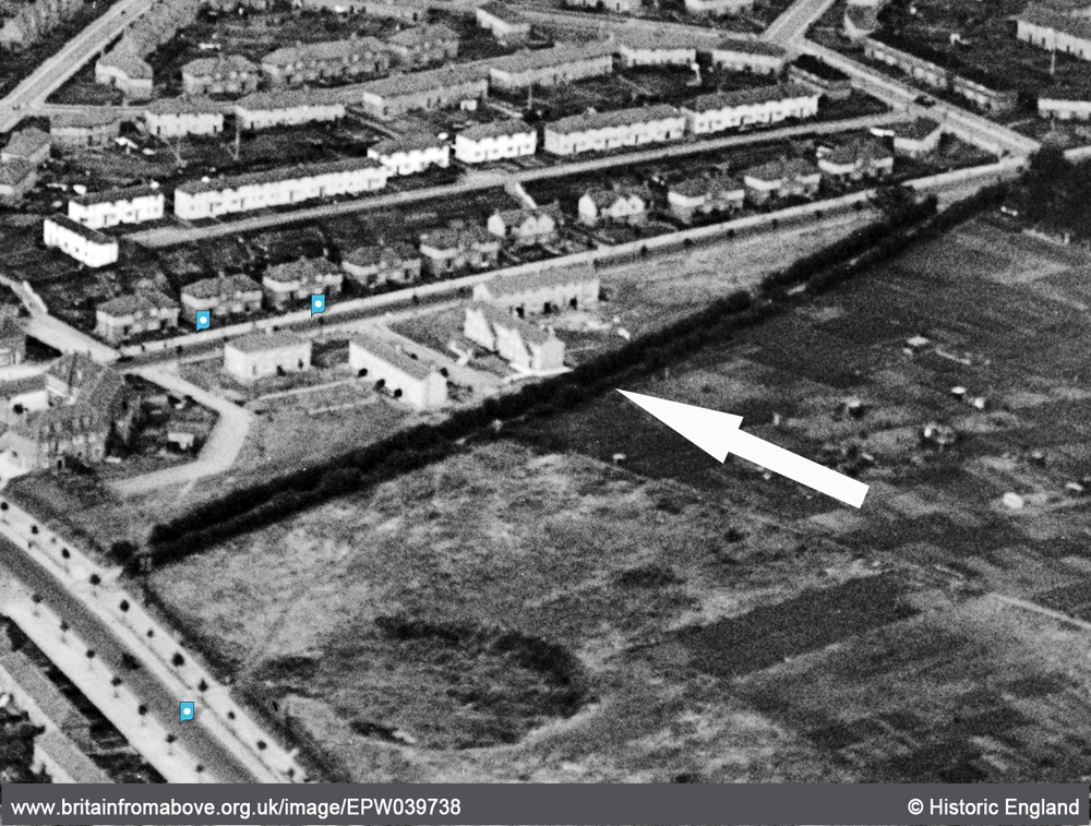
The lower half of Half Mile Lane running from Mile Cross Road (top right) to Drayton Road (bottom left), now lost under the gardens of the later added homes of Shorncliffe Avenue. In this imagethe fields have been replaced by houses to the west and allotments to the east, and the northern half of the lane has been repurposed as Mile Cross Road.
Why this particular little country lane with no buildings along it had intrigued me so much is anyone’s guess, but when I started searching for any references to it I wasn’t really expecting to find anything. To my delight I kept finding the road mentioned in newspaper articles from the early 1900’s, which only helped to feed my curiosities further. The lane was not completely forgotten by the passing of time either and two later-added roads, part of the “Mill Hill” extension to Mile Cross estate; Half Mile Road and Half Mile Close were named after it, even though they don’t mirror it. On top of this, although the old Half Mile Lane no longer exists in name, many of us have regularly and unwittingly travelled the northernmost half of it as we walk or drive along the later-added Mile Cross Road.
How do you write a piece about a man you’ve never actually seen a photograph of but know so much detail about? It’s quite hard and this is why I love historical photography, particularly photographs of people. If the subject is looking at the camera you can see into their eyes. Even if they’re no longer with us you can almost get a sense for the soul lurking behind those eyes looking back at you across the years. Unfortunately I can’t make this particular connection with the man I’m about to talk about and it troubles me a little.
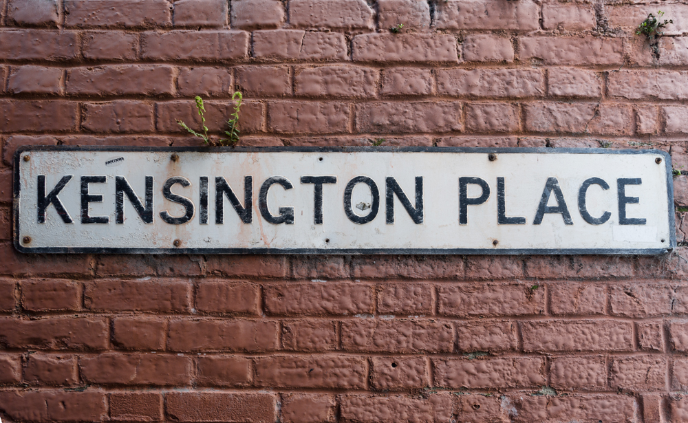
Albert Bayes came into this world on the 13th May 1890 at 4 Kensington Place, Lakenham and the life that was mapped out before this particular Lakenham boy was going to be something of a rollercoaster, which I’m going to delve into shortly; but as is often the case when I look into the history of people, I get side-tracked and stumble across hidden little corners of Norwich I’d never considered and this is the case here. The Kensington Place in which Albert was born only really survives in name these days as the tightly-packed double-row of houses, accessed by a small entrance off Queens Road have been swept away for some 1960’s un-improvements. However, the original entrance alleyway still survives along with the only real clue to it’s former use in an old yard-style name-plate, but it’s a blink and you’ll miss it affair as it’s so tiny.
It’s interesting to think that this tight little alleyway was once the main entrance to so many houses on a piece of land sandwiched between City Road, Hall Road and Queens Road and only a stones-throw from St Mark’s Church where a young Albert would have been christened. Unlike the cramped yards of the era, these houses looked as though they had a little bit of outside space, both front and rear and a chance at some good amounts of daylight once you’d entered through the tiny alleyway. As I stood in that tiny, little conduit taking the photograph below I could almost feel the ghosts of young Albert and the rest of his family brushing by as they made their way in an out of their home over a century previously.
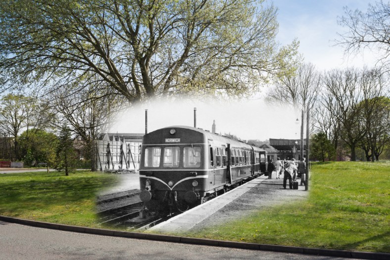
It’s hard to imagine that there used to be a Railway Terminus for passengers situated almost slap-bang in the very heart of our city centre, but this was the case up until 1916. At the very top of St Stephens and opposite what is now the Bus Station was the Great Eastern Railway-owned Victoria Station. It operated from this site for 67 years serving passenger links to London, but trains were to operate from here for much much longer than that. Victoria Station opened in 1849 and although the passengers stopped coming and going in 1916, the station evolved into a busy goods station enabling it to survive right up until 1966, and beyond. It actually survived even longer than that, albeit only as a coal depot and from the other side of the road where the Sainsbury’s supermarket now sits. Continue reading “The Ghosts of Victoria”→
I don’t normally dedicate a whole blog post to just one photograph, particularly one not taken inside Mile Cross, but this one has some history with a bit of a rant attached, and because the blurb for the original photograph on Flickr started to resemble a blog entry in itself, I thought I might as well drag it out a little for the sake of my sanity. Read on. Continue reading “A ghost redone, redone. And a point, laboured…”→