The wandering wonderer. I’m often wandering about Norwich with my camera in hand and my head in two separate places, usually the same space but in two completely different time-zones. No, not like you used to see in those 1980’s movies where some Fleet-Street shyster dressed in a suite that needed a volume control, who has three or four clocks on the wall behind him showing New York, London and Japan whilst he arrogantly barks down a mobile phone the size of a breeze-block. My head can be found wandering and wondering through and across completely different sets of decades, or floating between completely different centuries.
I’ve always been fascinated by the change in my local surroundings, probably to the point of being a bit obsessed by it. I’ve just never been able to put a finger on it or be able to properly articulate what it is going on inside my bashed-up head (both metaphorically and physically), but whenever I stop for five minutes to take in my landscape there’s a curious little voice constantly wittering away in the background. It’s the voice of the little caretaker we all have lurking in the dusty corners of our brains, talking to itself, worrying, wondering, planning, occasionally hoping, and when it’s really bored, digging out those really random songs from the jukebox of memories. You know what I mean, that moment when you’re brushing your teeth and it decides that it is now the perfect time to play you: “It’s Grim Up North” by the JAMs, or the theme tune to an unforgotten TV advert from 1987.
Well, my little brain caretaker has been working on overtime since writing a recent piece about Old Farm Lane and what that quiet little road used to be, long before the estate and all its houses turned up on the scene. On my recent travels in, out and through the Mile Cross Estate, my mind has been stuck firmly in the past whilst at the same time navigating the present. My imagination has been trying its very hardest to strip back all the layers built up over time; brushing away all the houses, the tarmac, the cars, the streetlights and all of those other things that have somewhat rudely trespassed onto this once-empty, rural land over the relatively short period of time that has passed whilst humankind has made rapid and massive impacts on the land beneath our feet.
What was here back then? What did it look like? Where did it go? Why did certain parts survive whilst other parts didn’t? How did the landscape affect where we are today? As I sit here in my warm home on a cold winter’s evening, I look down at my feet and my mind looks through the carpet, through the floor, through the footings of the house and focuses in on the brown and clumpy soil that is just a matter of inches below. It’s all too easy for my mind to imagine it, gone are my modern surroundings and I’m now stood in a cold and dark field, wishing that I had some boots on, or that I was writing this on a warm summer’s afternoon.
Luckily for me, I don’t have to just rely on my overly-active imagination to picture what was here before, or constantly reach for long-winded and rambling analogies to get a point across to myself. We now live in an age where maps and images are plentiful and easily available to most. If we know where to look and how to use the resources out there, there’s usually an easier way of bringing some of the past into clearer focus.
First up are the multitude of old maps available online, multiple websites give you the means to look at old maps through the years and they’re mostly free to use. I find that some maps are better than others, particularly those drawn up by the Victorian cartographers and these are often the maps I reach for first. The late Victorian maps are accurate, well drawn and often rich in detail, even showing us the location of individual and prominent trees. Trees, such as oak tend to live for centuries and can be a very good way of pinpointing where something was in the past, or still is now, as long as the tree hasn’t been felled by progress or nature. Even if the tree has since been felled it might appear on an old photograph, meaning we have two or three points of reference. It’s not just the mature trees that make for great reference points either, field boundaries were often lined with hedges and/or fencing (usually the former as they were cheap and easier to maintain) meaning that aerial photographs literally have the field boundaries drawn on to them with hedgerows, just like the maps.
Take Sloughbottom Park for example, it’s almost the exact same shape as the pair of fields it was placed upon. The same goes for both the Sweetbriar Industrial and Whiffler industrial estates. By using these field lines on old maps coupled with the old photographs you can make out exactly where somewhere, like Mile Cross, sat on the landscape in the future (if that makes any sense), and combined with any surviving trees, you can see with complete accuracy where some of that stuff used be, right under our feet.
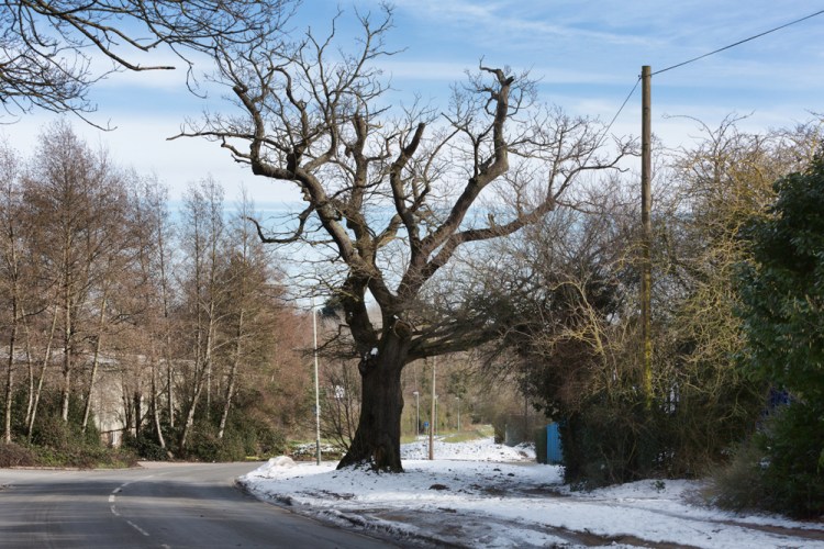
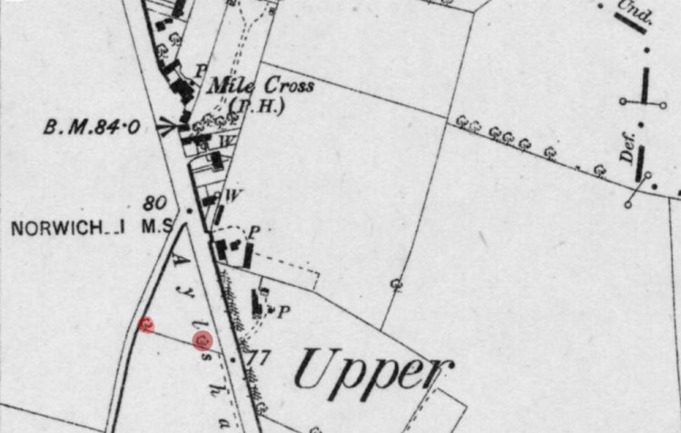
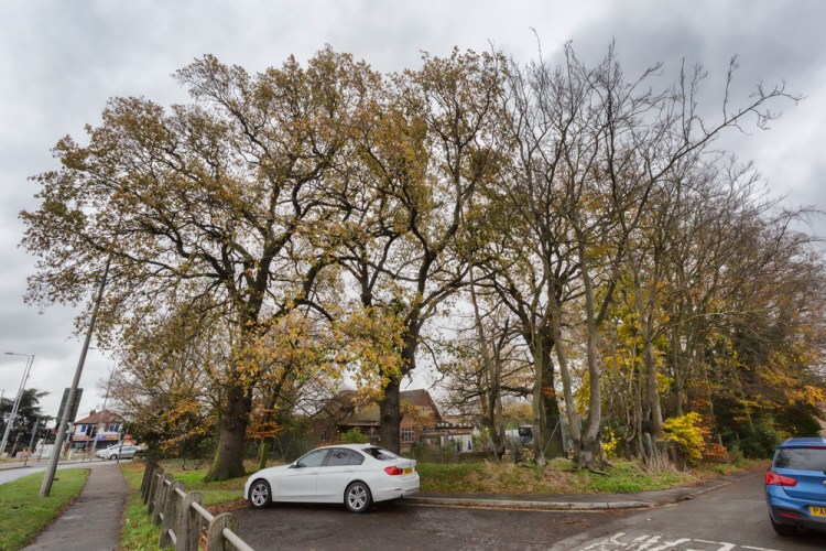
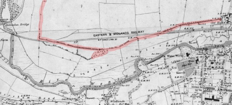
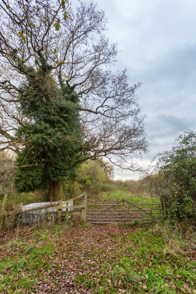
Take the below images as an example. First up is an OS map from about 1880, showing us the triangle of land hemmed in by Drayton Road, Sweetbriar Lane and Hellesdon Hall Road. Highlighted on it in red are four already mature oak trees that can still be found sitting in their landscape to this day, 140 years or so later.
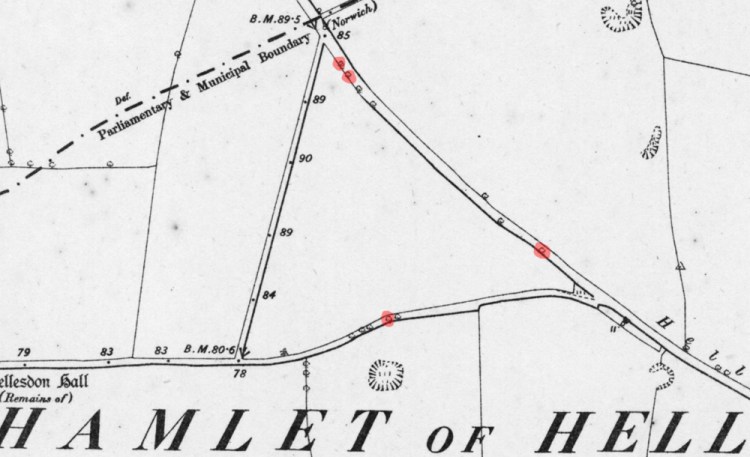
Next up is a photograph which was taken from the air, about fifty years after the Victorian map (above) was drawn up, and we can see that very same triangle of land, a corn field, which it was right up until the late 1980’s. If you look at the boundaries of this triangular field you can see some large oak trees that have survived the next 50 years after the map was drawn up and all the progress that came with the eighteen and nineteen hundreds. What’s even more interesting is that those trees (arrowed) are still going strong today and I have estimated that they are at least 300 years old, probably older.
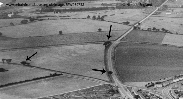
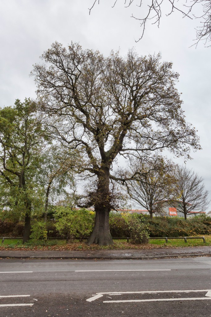
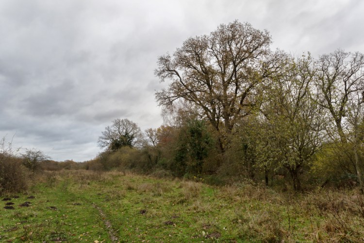
This following image is of the oak tree at the bottom of the above aerial image, on the edge of the field opposite what is now Whiffler Road. The taller trees surrounding it are much younger, planted in the 1920’s and 30’s. The field of corn behind it has mostly succumbed to factories, but a little slice of that countryside, now a lot more wild than it was when it was farmed, is still quietly waiting to be expanded onto.
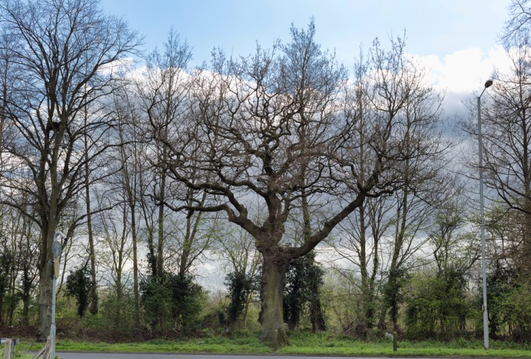
I used to call this old tree ‘Mile Cross Oak’ and regularly thought about looking into it and possibly writing something about it, not really putting too much thought in to how to write something meaningful. What I also hadn’t considered was the possibility that there might be others just like it, standing nearby. Until now that is. When you take a wider view of the scene you’ll see that the neatly planted lines of Linden Trees of the 1920’s are evenly spaced to incorporate this old oak nicely. In the below image we can see the line of trees, including the oak from the other side of the field, taken from Hellesdon Hall Road as it heads up towards another old tree.
On the opposite side of that same field, stands the tree pictured below and it is the tree arrowed on the left hand side of that earlier aerial image and the bottom of the map, about two thirds of the way along Hellesdon Hall Road. Unfortunately, this tree now stands alone, it’s siblings having been felled by man or wind as the fields surrounding it have been rapidly filled in with characterless factories over the last fifty years.
The old country road that this tree stood watching over for at least three centuries is now half industrial estate, half cycle path. This scene is a far cry now from how it must have looked during the days when it would have mostly been used by the residents of Hellesdon Village and local farmers to make their way in and out of the City. The area around this old tree feels as if it’s in a bit of limbo, neither here nor there. Standing in the shadow of this tree you (well I) can still sense the countryside that belonged to this tree (or vice-versa), but it’s no longer here. The field to the right was lost in the 1970’s under the industrial estate and corn field (pictured above) was still being farmed until the early nineties, until it was sold off to make way for a double-glazed windows factory, if I remember it correctly.
Until the 1970’s there was a great view to be had over the city from up here by this old oak, before the remaining fields were filled in with Industrial Estate and obscuring the old view for good, unless you were willing to climb the tree, of course. Speaking of the old tree, you can see that despite its roughly 300-year old girth, it has a few tell-tale signs, such as gnarled and exposed roots, signs of decay, hollow areas and looking in poor shape (which actually means quite the opposite) that hint that it is likely to be even older than that (if what I read on a website about working out a rough age of native British oak trees was correct) and there’s also evidence of work being done to it at least a hundred years ago, possibly by one of the farmers talked about in the last piece.
The last arrow at the top of that aerial photograph and shown on that first map (shown above), points to two oak trees at the top of Drayton Road, close to the junction with Sweetbriar and unlike the lone tree a bit further down the road, these two oaks are now mostly hidden behind the later-planted Linden trees that were planted by Captain Sandys-Winsch in the 1920’s.
Sandys-Winsch was responsible for the planting of some 20,000 trees in and around Norwich which we, as residents of the city a century later, are now beginning to reap the rewards of. His trees line the verges of most of the important routes in and out of the city, Drayton Road being one of them.
These two hidden oak trees were right on the boundary of the city at the junction with Sweetbriar Lane and these old guardians have been keeping a watchful gaze over this entrance to the city for hundreds of years. Like the other trees nearby, this pair must have witnessed rapid change over the last one hundred years. The fact that that despite their size and age they’re now almost invisible in the summer months when the younger trees are in full leaf proves this point more than anything I can type about the changes they’ve witnessed.
After measuring the collection of oaks mentioned above I worked out that they must date back to at least the turn of the 1700’s/1800’s, however this is a very conservative estimate based solely on the width of the trunks, which isn’t always the most reliable way of figuring out the age of an oak. After reading up on the subject, I suspect that they are all a fair bit older, mainly because of the gnarly condition of the trunks and upper branches and because they were already large trees back in the early 1900’s. The fact that they were notable as large-enough trees to gain the attention of the cartographer and appear as mature trees on the maps of the 1880’s makes me think that they must have already been a fair age by then. A good way to judge the growth rate of multiple local oaks in 50 years can be found all along the edges of the Marriott’s Way, which closed to trains in 1969. The many oaks that have sprung up along there, assuming they started to grow in about 1970, are similarly sized and still quite small considering they are aged about 50-60 years, however, I’m far from an expert on the subject.
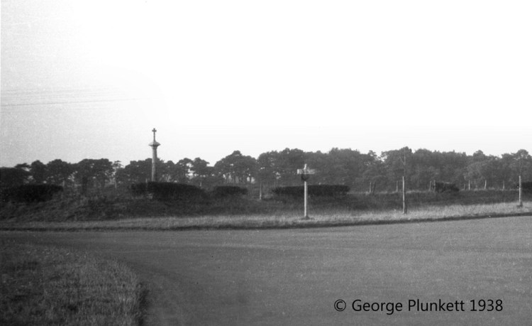
Just across the road from this pair of ancient trees is something man-made that is older than they are (the parts of it that are still original, that is) in the form of the old boundary cross, which stands diagonally across the road and in the shadow of the neon glare of Asda. The plaque upon this old boundary cross reads “This Boundary Cross was erected in the 15th Century to mark the spot at which the King’s Way crossed the Norwich City Boundary”:
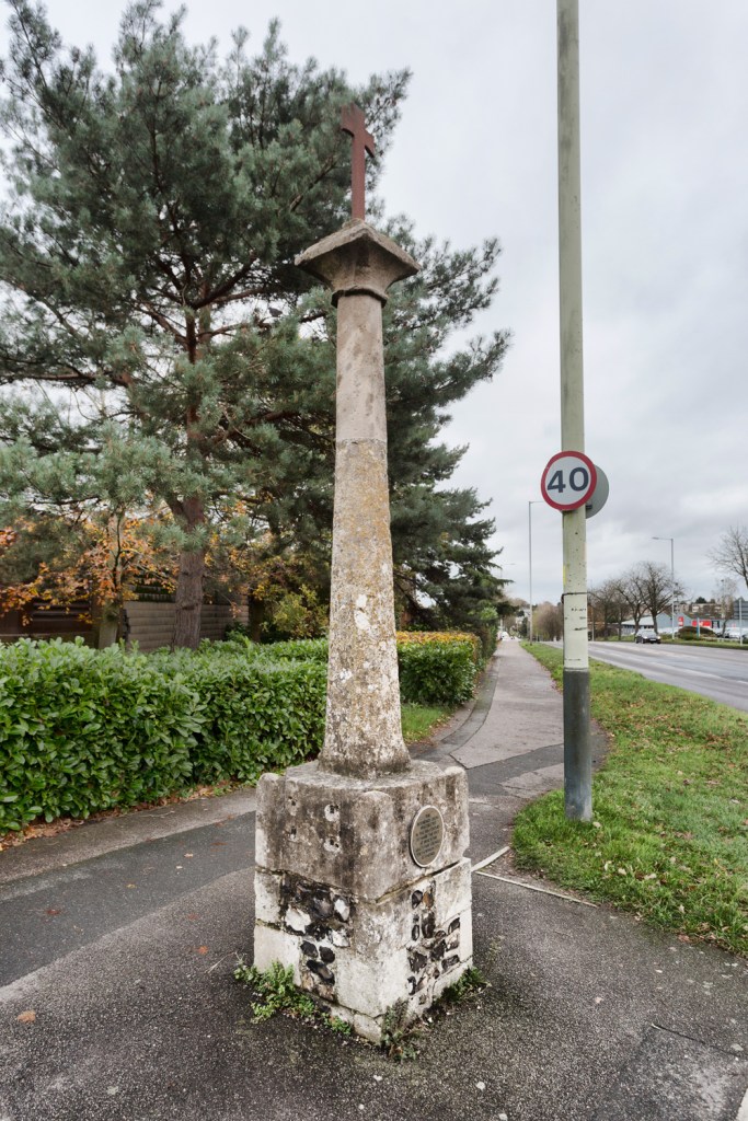
Like those oak trees nearby, this old cross no longer stands as mark of where city ends and the countryside starts and below is a picture of it hiding behind a line of bushes that formed one of the boundaries to another field where Asda now stands. In the distance behind it can be seen the old Boundary Wood, parts of which are still there today, almost. Plunkett’s photograph really rams home how quickly the countryside around those old oak trees was swallowed up by the twentieth century. The ring road looks a lot quieter back then than it does today and this image should serve as a warning for what will happen to the fields inside the NDR (sorry, Broadland Northway) and the countryside bordering it.
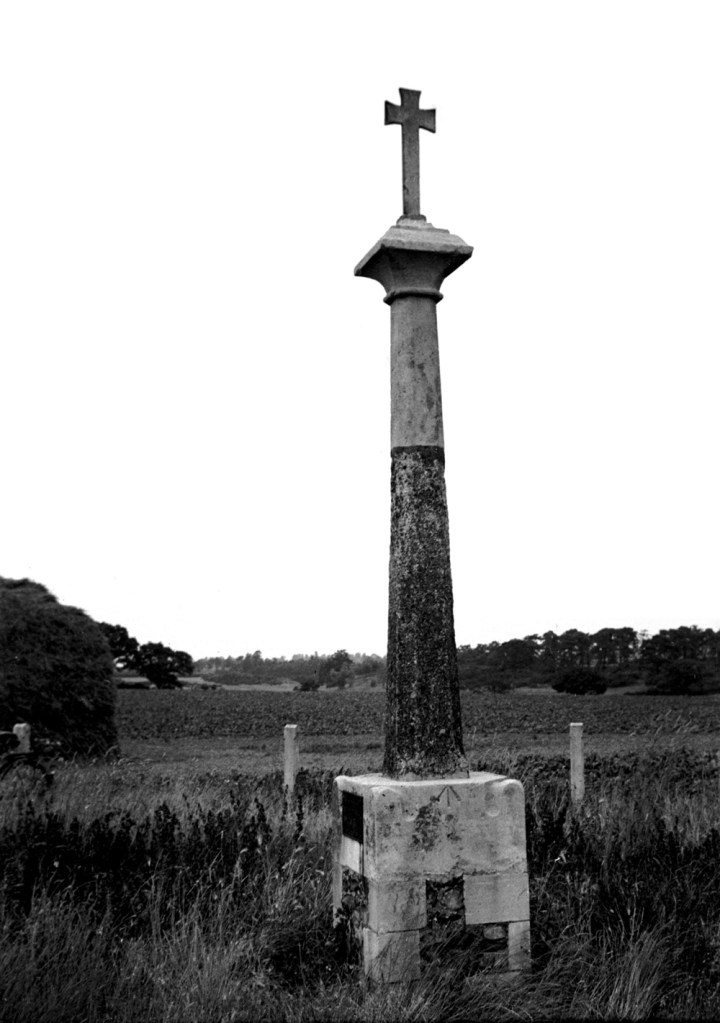
Below is another George Plunkett photograph of the boundary cross from the 1930’s, this time a close up, which not only shows that the cross still looks exactly same as it does almost nine decades later, despite being narrowly-missed by the incessant flow of increasingly-fast moving traffic and being belched-upon by toxic fumes, but also giving us another good view of the fields and trees in the background. This rural scene is now long gone, swallowed up by retail on an industrial scale, paved over to make way for Asda and the former Sports Village. I have a vague memory of looking into this field when I was very young in the early 1980’s and this is how I think I remember it. The greens of the golf course can also be seen, left of centre and these pieces of green are currently succumbing to the same fate as the fields, this time to make way for more housing which will further distance Mile Cross from the welcome countryside that used to border it.
There are actually three of these crosses surviving in this part of Norwich, two of them in or next to Mile Cross, although the one up at the boundary only survives as a base, its sad remains relocated after it was smashed to pieces by a lorry back in the 1950’s. It’s little stump now sits next to the entrance door of the Boundary Pub and in my opinion, this is something that needs to be put back together in one way or another as it’s an important, but neglected part of our local heritage. Perhaps this is something I should think about raising with the council in the future.
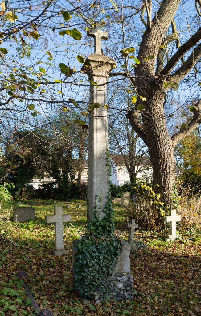
The third remaining cross stands tall in the churchyard at St Mary’s, Hellesdon and is clearly denoted on the maps as being stood on the old boundary line separating the City and County as it cuts across fields. It could easily be mistaken for the grave of somebody wealthy, standing as it does in amongst the gravestones of this fascinating little churchyard:
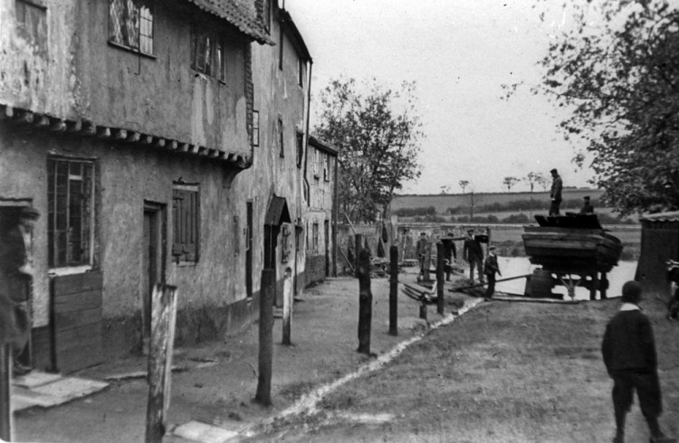
At the very beginning of this piece I was talking about trying to imagine that clumpy soil right here beneath my feet as I sit at the desk in the corner of my living room, luckily I have the means to actually picture the scene without also imagining getting cold and muddy feet. A year or so ago I was sent a fascinating photograph by the wonderful Colonel Unthank when writing a piece about back river. So interesting was the picture of the following scene (taken at Heigham Watering) I didn’t immediately realise that in the background were the actual the fields that made way for the building of a large chunk of the Mile Cross housing estate, including the spot at which I’m sat right now typing all this. The picture below is the perfect example of how we can spot interesting stuff in the background of a luckily coincidental photograph. It wasn’t until I revisited this old image in Photoshop to look at the railway line, that I realised the fascinating background details hiding in full view in an already fascinating scene.
If we zoom in to those fields climbing up the other side of the valley past the river and railway line we can spot some nice little clues as to what we are looking at, and coupled with the detail on the old Victorian maps, I can accurately pinpoint parts of the modern landscape. In the below crop of the above image I’ve highlighted a few points of interest with some less-than-subtle arrows.
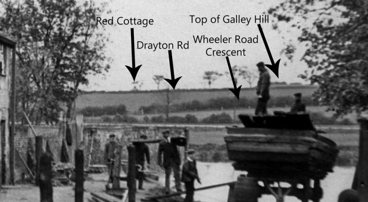
Starting from Left to Right we first come to a roof and a chimney which when lined up using the old maps, points to the top of what was the Red Cottage at Slough Bottom. This old cottage stood by the road close to the entrance of Sloughbottom Park, which had yet to be built in this image and was until Mile Cross turned up the only building in that area. The next arrow highlights a long row of hedges running along the horizon that mark the edge of the field boundary that ran along the southern side of Drayton Road as it climbed back out of the slough bottom and heads towards the city. None of those trees we can see in the image survived, most likely felled to make way for the new estate, but they are marked on the Victorian map. The tallest one standing almost outside my dad’s house and the one in which I grew up. The third arrow is pointing at another hedge-lined field boundary, running from the railway line up to the high point of Drayton Road, before it starts to slope back down towards the roundabout, just beyond the junction with Parr and Bignold Roads. Using this obvious field boundary running towards the railway I was able to ascertain exactly what was built on top of it years later, the middle arrow pointing out the spot where the crescent of houses surrounding the little green on Wheeler Road were built. The field to the left of it is where my current house now stands with it’s good views across the Valley to Heigham. The last arrow in the image is pointing to an even higher piece of land behind Drayton Road, which is the land at the very top of Galley Hill, where a pair of lofty Mile Cross houses now face the triangular green between Galley Hill And Bowers Avenue. It’s fascinating (to me at least) to think that I have spent most of the last 40 years living on top of those very fields.
Using the same process as above I moved on to yet another wonderful photograph given to me by Colonel Unthank, this time taken on the banks of Horseshoe Bend at some point before 1922. In this image we can see those same fields and their boundary hedges again, only from a slightly different angle, with a wider viewpoint and not obscured by any buildings.
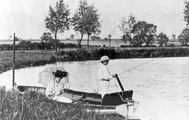
Zooming in to the background of this lovely old scene shows up more little pointers of what we are looking at in the future. I’ll start again looking at the arrows going from from left to right.
The first arrow is pointing to fields that were to become the wider part of Sloughbottom Park at it’s southern end (also the Mile Cross school playing fields and allotments). The second arrow is pointing to a large haystack that is standing in roughly the same spot as the house now standing at 186 Drayton Road. The third arrow is pointing to a slightly elevated old oak that was probably felled to make way for houses along Margaret Paston Avenue. The fourth arrow is showing the long hedgerow marking the boundary between the fields and Drayton Road, roughly at the point where the speed camera now stands. The last arrow is pointing to the area where the Parade of Shops and roundabout now stand at Drayton Road and Mile Cross Road.
The details gleaned from studying the above collection of images just serves to ram home why I really love poring and obsessing over old photographs and maps. It’s amazing what you can find when you do a bit (a lot) of digging and begin to tie all these little clues altogether and can really help to paint a broader picture of the past and it’s future, or the present.
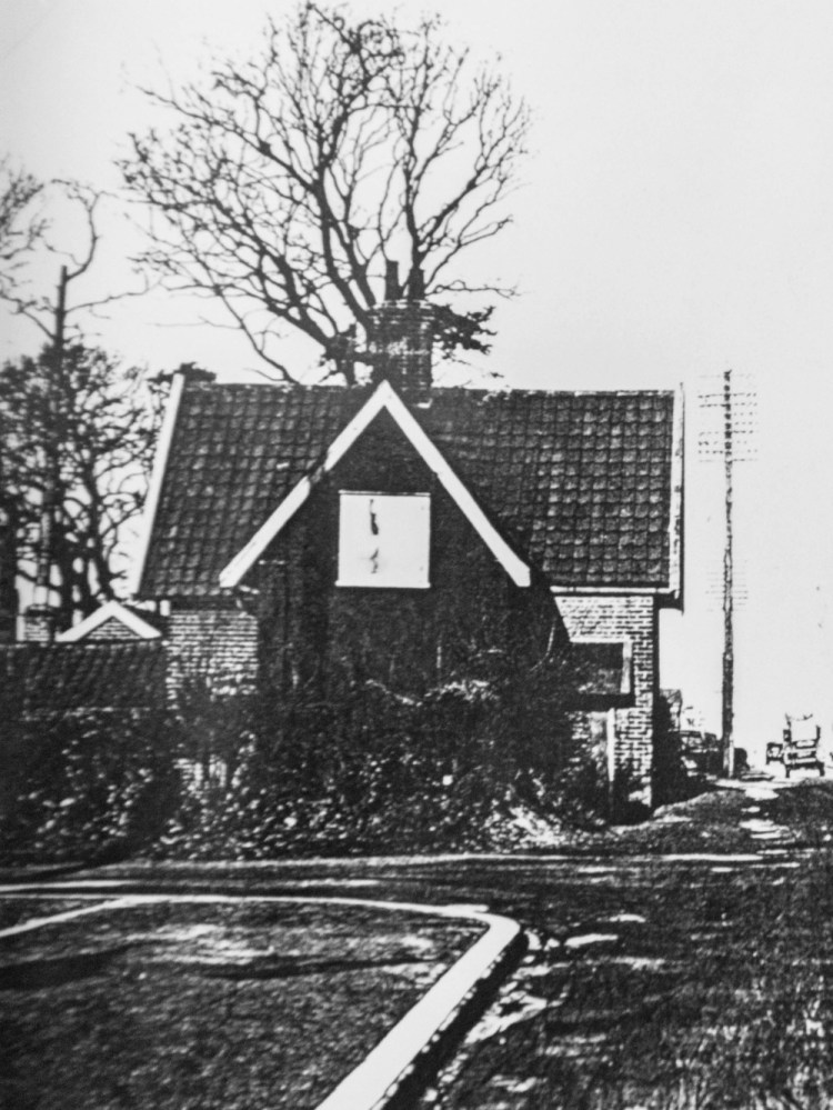
Moving on to that lonely building that can just about be mad out, poking its rooftop out of the undulating landscape in the first of the above two images. The Red Cottage sat in the natural depression known as the Slough Bottom. This building was a house or pair of houses was known as the Red Cottage/Red Cottages. They sat almost at the bottom of the slough, close to the junction with Hellesdon Hall Road, roughly where the car park for Sloughbottom Park now sits. Going by some of the old news articles it appears there had been a cottage here since at least the early 1800’s and some of the residents had worked for the nearby farmer Gowing, the fields of which their house backed on to. This attractive-looking building stood right by Drayton Road, almost opposite the Galley Hill Pub until the 1960’s or 1970’s when it was demolished to make way for three rows of fairly small homes, sandwiched between Drayton Road and the allotments at Valpy Avenue.
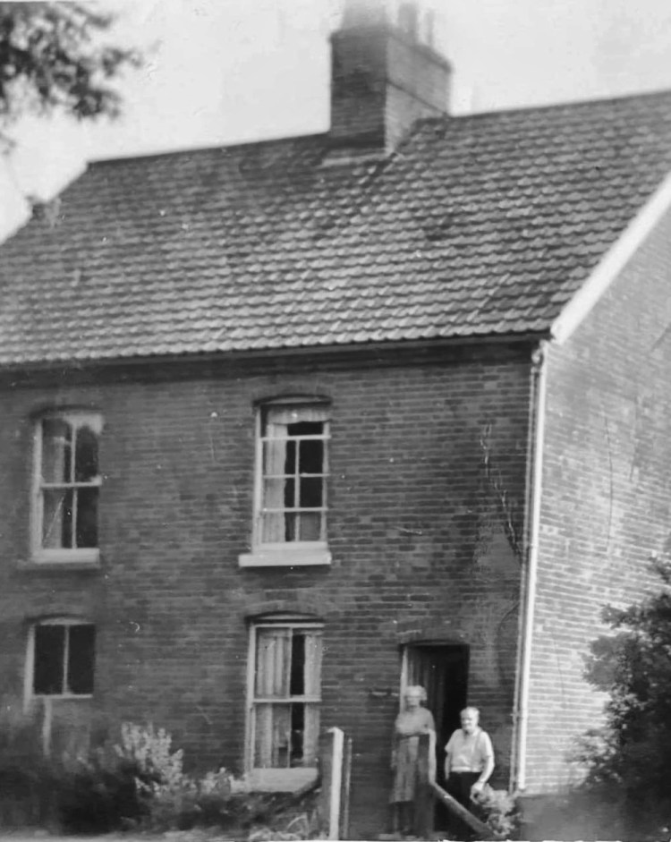
Staying here at the natural depression known as the slough (now Sloughbottom) for a bit, this particular dip in the landscape sits at the foot of the ridge we know as the Galley Hills is an interesting quirk of geology. It’s quite deep when you view it from the right angle, something touched upon briefly by Matthew Williams in his fascinating book: Subterranean Norwich. It looks even deeper when viewed from the heights of Galley Hill and you can see why in the past it was prone to be filling up with water and becoming a pain for pedestrians and horse-drawn carts to navigate at times. There are numerous letter submitted to the local papers of the time where people have decided to put pen to paper to complain about the state of the roadway down at the bottom. One of the meanings for the word “slough” is “hole or depression”. The newer houses here are named after the old Red Cottages, known as “Red Cottage Close”.
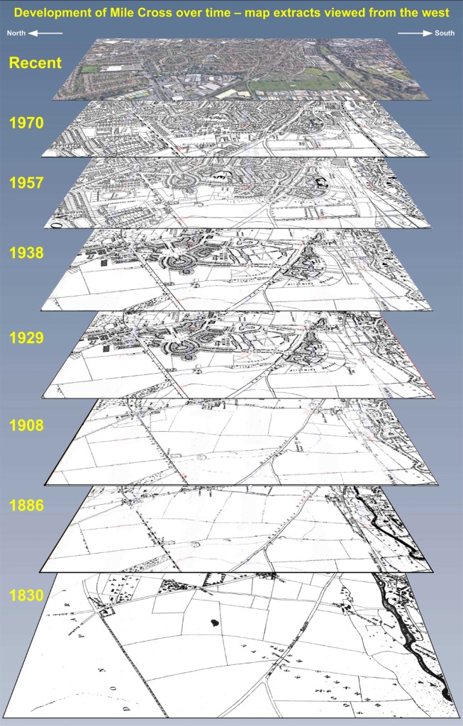
Speaking of Matt Williams, he recently created a couple of really interesting and useful images of the area for a Mile Cross project that was curtailed somewhat by the recent and ongoing Covid pandemic. Because our plans had to evolve this pair of images have yet to be used in any meaningful way, so Matt has kindly agreed to allow me to use them for this piece. The first image can be seen below which demonstrates rather nicely how the land here at Mile Cross has been built upon over the last 200 years. The second image we’ll come to later.
This first image created by Matt is a layer cake of maps, expanded through recent history to highlight what I’ve been trying to articulate throughout this piece, showing how the use of the land here, right beneath our feet has changed over the last couple of centuries and it really helps to show how Mile Cross has emerged from those fields shown in the background of some of those images above. It also serves as another reminder to the city’s ever expanding waistline as it bursts out and over old boundaries, spreading further and further out into the surrounding green bits, like the gentle lapping of the waves of an incoming tide. This again acts as a worrying glimpse to the future of all the green bits recently hemmed in by the NDR and how they will be inevitably and quickly filled in by human expansion.
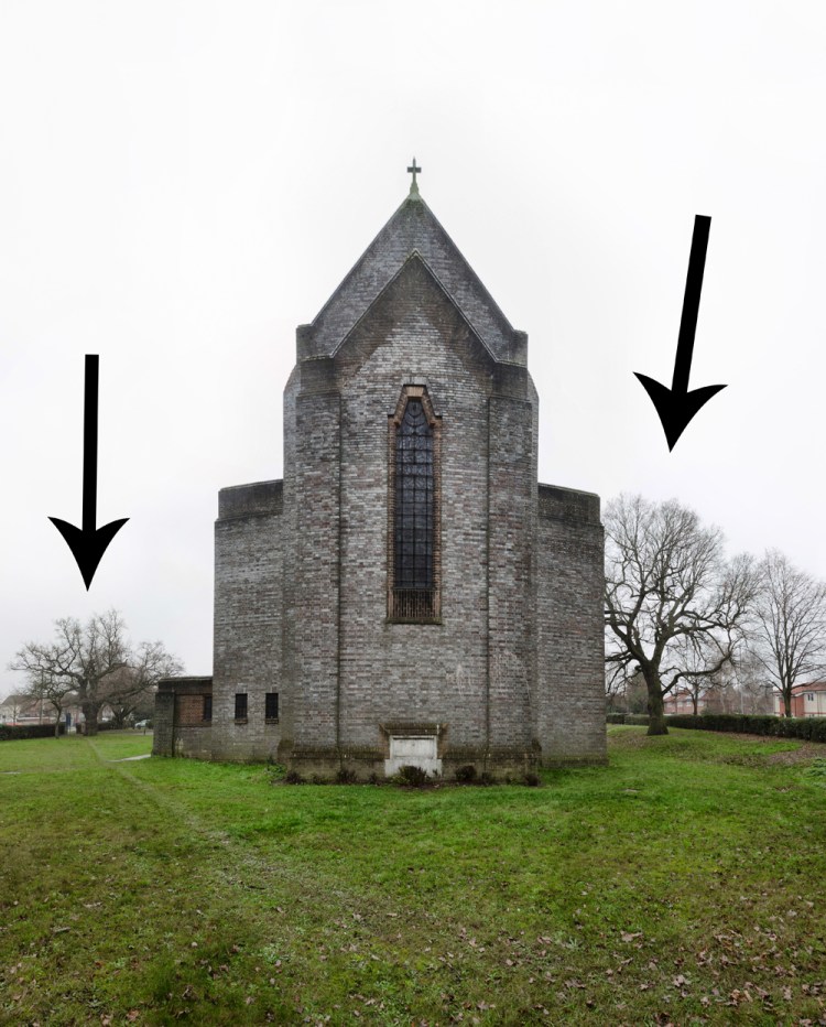
Buoyed by what I’d found in the old images and maps above, I decided to widen my search, looking for further hints and remnants of the landscape before the estate appeared. Surprisingly, for someone who claims to know so much about the area, the more I looked, the more I began to see interesting and fairly obvious bits and pieces that I hadn’t really picked up on until now. Taking a closer look at the trees here in Mile Cross, I soon noticed that there was another large and mature oak, this time standing right next to the relatively new church of St Catherine’s. It’s mad to think I’d never really noticed it before, seeing as I’ve spent quite a bit of time photographing the church for various historical projects, but its a great reminder of how these clues can be right under, or in this case completely towering over your nose. Amusingly, for me at least, It wasn’t until I went to take a photograph of this particular oak for this piece that I noticed there was actually a pair of them.
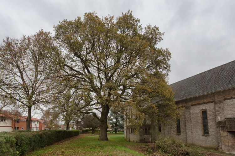
The second oak doesn’t quite have the height of its sibling, but its trunk is just as wide and it has a wider spread, meaning they’re probably of a similar age. Once again, the old Victorian maps backed up that this pair of oaks were already mature all those years ago, standing together in a triangular field between Half Mile Lane and the Aylsham Toll Pike with only each other for company.
This particular pair of oak trees have stood here far longer than the Church of St Catherine’s that they now compliment and have even stood here longer than the Hellesdon Mission Hall that preceded that. They might even be nearly as old as the bells that were rehomed inside the current belfry of St Catherine’s.
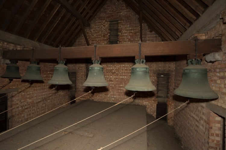
This set of old bells have only been here in Mile Cross for a relatively short period compared to the trees nearby and came from the much older round towered church of St Mary’s at Coslany. When St Catherine’s Church was being was built to compliment the new estate in 1936 it was decided that it would make for a great place to relocate them. Interestingly, these bells are said to be the oldest in Norwich, some of which can be dated back to before the reformation and some a hundred or so years later. The Bells are hung in their new tower ‘dead’, meaning that instead of being swung by ropes to make their chimes, they are instead rung by being struck with a set of hammers attached to a pulley system. Recently, I was lucky enough to be allowed to ring these bells and surprisingly I managed to keep up a good tune, my chimes no doubt annoying/delighting some people across the estate on a Saturday lunch time, which was a nice experience. For me at least.
In the below map from 1880 we can see these two old trees marked on their triangular plot just by the side of what was Half Mile Lane (now Mile Cross Road) and Aylsham Road.
These old bells were sold to St Catherine’s after the recently refurbished, but ancient tower at St Mary’s was deemed unsuitable to be able to house and ring them safely any more. The two images below show the old bells hung dead inside the tower of St Catherine’s with their ropes all heading towards a pulley system, operated from a little cupboard hidden neatly behind the scenes of the church at ground level:
And a close-up of one of the newer bells, which probably isn’t too much older than the pair of old trees currently still stood outside in the church grounds:

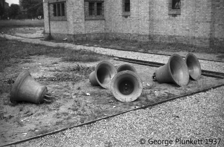
The picture below, taken by George Plunkett in 1937 is of the very same set of bells, sat on the grass outsdie the newly-built church, waiting to be hoisted into their new home, high up in the belfry of St Catherine’s:
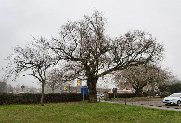
The below, wide shot of St Catherine’s shows the church in the foreground and the trees bordering the two roads that help form the triangle of land. The nature of this merged, wide angle shot makes them look smaller than they really are, but it’s nice that they still stand proud after all these years and help compliment the new (relatively speaking) church. This pair of wise old trees might even outlive the church itself. Who Knows.
Leaving St Catherine’s and its old trees behind, my wandering feet, being led by my wondering brain takes me north, heading up Aylsham Road to the boundary where I find even more old trees. This time an impressive collection of towering old oaks, surrounding the southern edges of the beer garden of the Boundary Inn Pub, another relatively new building on the landscape when viewed from the perspective of a mature old oak, and like all of the other trees discussed so far, these trees are much older than the building they now currently stand guard over. The pub was built in about 1927 on a piece of land that looks as though it had various uses over the years, possibly linked to the old old toll house and its adjoining property. I’m not entirely sure why these particular trees were planted in such a fashion all those years ago but they look as though they had been purposefully planted to completely surround this portion of land straddling the old boundary, but the building they surrounded on the tithes map were not ‘inhabited’, meaning it could have been a barn, or even an old summer house sat in a fairly large set of gardens. Maybe this land and its trees were something to do with the Hellesdon Poor House which was located just across the road (now a conservatory showroom). Whatever the reasoning behind their planting hundreds of years ago, a large portion of them still stand tall up here at the northernmost entrance to the City, hinting at what was here long before the estate that was named in honour of it.
This following image, taken before the Boundary Inn was built, shows the old toll house that stood at the entrance to the city. This old turnpike was demolished in about 1925 and its land cleared to make way for the new Boundary Inn. The old trees were kept, most of which still stand proud to this day, and can be seen towering over the old view of the boundary from almost a century ago, below:
If you stand up at the high ground of the boundary and look back down Boundary Road towards Asda, you’ll see yet another large oak, trying (badly) to hide in amongst the later-planted horse chestnuts, like a giraffe trying to hide in amongst some zebra. This particular tree is considerably taller than its 1920’s neighbours and is standing outside what is now the site of the large DIY store, B&Q. When I looked into this particular tree using the old maps and aerial photographs, it helped me to identify the exact location of something else that is no longer there.
Going by the aerial photograph below you can see that this impressively tall oak was already very tall in the 1940’s, towering well above the later-planted trees (as it still does now) and we can also see that is stood right by the entrance road to the Boundary Park Greyhound racing stadium, which opened in 1932. Interestingly, this large stadium very nearly became the new home for Norwich City Football Club when they literally had to fly The Nest, but instead they chose to settle at Carrow Road. However, there was a floodlit football pitch located on the inside of this race track on our boundary and it was used by the Canaries on occasion, particularly by their reserve team. The whole site is now lost under the B&Q and the old oak tree is the only reminder to what was here before. To put things into perspective, this old oak would have stood here long before the city had a football team, long before football was a sport as we now know it and long before the city itself had any ideas of venturing anywhere near it. Like the other old oaks in this piece, this old tree was planted to help denote the boundary of a quiet country lane surrounded by fields, long before humanity even had a real understanding of electricity, and it’ll still be standing there long after any of us reading this have shuffled off this mortal coil.
Speaking of very tall trees, the Boundary Park Oak will eventually pale into insignificance when compared with the following pair of trees, located at Old Farm Lane. They’re not oak trees this time, but something a little more exotic, in the old-fashioned sense of the word at least. This pair of Giant Redwoods were brought over form the Americas during the Victorian Era and made their way onto Mile Cross when a wealthy farmer decided that they would be the perfect way to show off his new Manor House and his wealth (a bit like buying a pointlessly enormous Vankervaggen to park on your driveway in 2022). This pair of still relatively young trees will tower well above anything in the local area once they start to mature proper and will most likely outlive the native old oak trees three times over, assuming the oaks will survive 1,000 years. These impressive trees could still be stood here in the year 5000. Just try and imagine that, I know my meagre brain struggles to comprehend it. That is, of course, if the planet hasn’t been made uninhabitable for them by then. Which is a very real possibility.
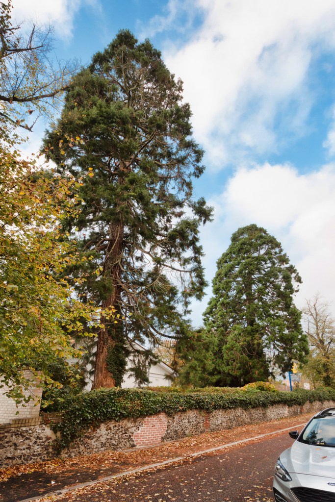
Like the old Boundary Park oak above, these trees here at Old Farm Lane are the only real reminders to what was here before, in this case the farm that once stood here long before Mile Cross was a housing estate and it was something I’ve written about in this earlier piece: “An old famer’s lane gets me wondering“.
Looking back again at this towering pair of trees for this latest piece helped me to find something else about the old farm here that surprised me a little, as I had completely missed it first time round. I’d only been really focusing on the Giant Redwoods stood here (apparently there’s a yew in there too, somewhere) and I hadn’t picked up on a really obvious line of purposely planted planted trees, heading west from the opposite side of the farm. These trees were planted next to a long farm track that ran all the way across the southern edge of Mile Cross to a plantation of trees located in the middle of the marshes at Sweetbriar. It then continued west to the opposite side of the marshes before turning abruptly north, ending at the other Gowing Farm at Hellesdon ‘New’ Hall. I was dubious at first as to whether this was an actual track until I spotted one map with altitude measurements running along it, meaning that the Victorian Cartographer had walked it and taken measurements, something they only ever did on roads or tracks.
Why was I surprised by this? Well firstly because it’s so bleeding obvious. I’ve spent far too much of my time poring over the local maps than is probably healthy over the last few years, I also revisited them countless times whilst writing that piece about Old Farm Lane/Hellesdon Old Hall and secondly, because It’s still visible today on the maps today, well most of it.
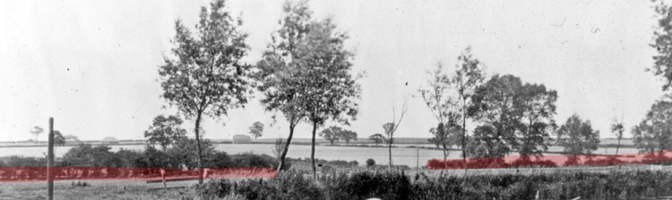
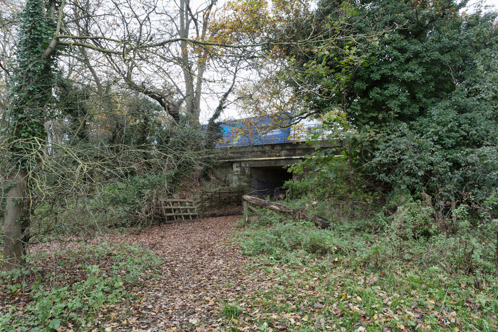
The old farm track can be seen on the map above, highlighted in red. Even back in 1883 it was no longer complete having been recently interrupted, twice, by the newly added Eastern & Midlands Railway line of 1882. Not only had the new railway line run right through the front garden of the old hall, it had somewhat inconveniently been laid right through some of the nearby fields, dissecting this old farm track in two places, meaning that there needed to be two occupational crossings added to the fields so that the farmers could safely follow the old track to and from the plantation and to move their cattle about. In the following crop of an earlier image we can see the line of the farmer’s track (again highlighted in red) where it was interrupted by the railway line and in the very bottom right you can see the white gate of one of those occupational railway crossings put in for the safety of the farmers. This crossing stood roughly where the entrance to Sloughbottom Park now is on the Marriott’s Way and the area today still feels a bit like a crossing, a heavy metal gate having to be navigated to take you across (over to the river path) or on to the Marriott’s Way and it’s constant stream of pedal – and foot – powered traffic.
If you head down there today to have look, you can still trace a large part of that old farmer’s lane on the other side of the former railway line and it becomes more obvious as you head further west. There are some very big clues to help you locate the farmers’ former footprints upon the landscape here, the biggest clues being namely in the form of – yes, you’ve guessed it – old oak trees.
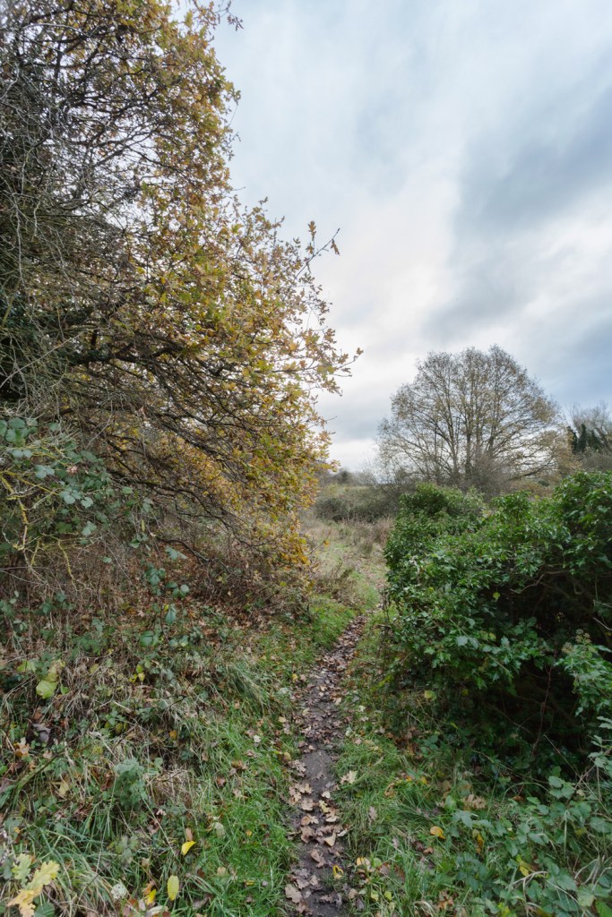
The first section of this old farmer’s track that had initially highlighted itself to my attention on the old maps has long since disappeared under the later additions of Mile Cross Road, the old council depot site and bottom of Sloughbottom Park, but after the point at which it was first dissected by the new (now old) Railway, we can pick it up again and almost follow it on foot, in some places at least. On the southern edge of the Marriott’s Way and bordering Mile Cross Marsh is a little path that I’ve been unwittingly following in the old farmers’ footsteps for years now and below is an image of it looking back towards the park. Marriott’s Way is immediately on the left here. The trees are of course Oak trees, but these are smaller, most likely descendants of the originals that have spread far and wide along the banks of the former railway line.
However, if we turn around and look west from the same spot there’s a gate straddling the old farmers track, that is now used to access the Marshes at Sweetbriar and on the left is a line of much older trees, mostly mature oaks that lined that old track as it headed off west across the marshes. The fairly large oak seen in the picture below also being one of those starring on those old maps from over 140 years ago.
Now, if you were inclined to hop the gate and follow this line of trees (I didn’t and I wouldn’t recommend it), they follow their old farmer’s track, now mostly overgrown, out into the middle marshes and up to the recently-added(ish) Sweetbriar Road of 1932, which was laid straight through the middle of the old tree plantation that this old track was heading towards. Instead of disturbing the local wildlife and risking getting myself stuck neck-deep in mud, I decided to take the longer route, heading west along the Marriott’s Way and clambering up the bank by the former railway bridge of 1932 up on to Sweetbriar Road. From there I headed south along the busy road for a few hundred feet before clambering back down the bank to pick up the old farmer’s track where it met the plantation of trees that once stood alone, completely isolated in the middle of the wide marshes.
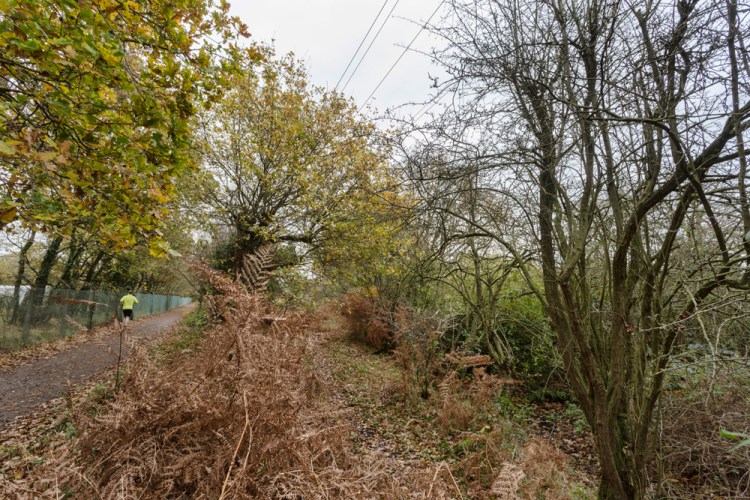
From the banks of the built-up roadway that had rudely interrupted the marshes back in the 1930’s I took the following image, looking back across the Marshes towards the point at which I’d taken the previous image, and the old farmers’ track can be easily identified by the line of remaining mature oak trees heading east across the marshes towards Sloughbottom.
This next image was taken slightly to the right of the image above, in amongst the trees and stood on top of the former farm track, looking back from Sweetbriar Road. You couldn’t realistically walk it now, even if you were allowed to, as it hasn’t been used properly since the railway turned up and the pair of farms it connected disappeared, but you can get a feel for it. Again, the purposefully planted old oak trees line the edges of the former track as it disappears off into the undergrowth. From this vantage point, I could almost feel the spirits of those old farmers passing me by as I stood here trying to picture the landscape before the new road and railway came crashing through to shatter the rural peace all those years ago.
The old track would have originally been used to access the plantation of trees, located in amongst the marsh, the remnants of which can still be seen below, looking east from the bottom of the banks of the built-up Sweetbriar Road as it cuts the marshes and the old plantation of trees in two.
Although the track had obviously been made redundant as an easily navigable path long before the road turned up, I was surprised to find that this point is marked by a bridge, showing that the old farmer’s track and wider access to the marshes was still considered when the newly-added ring-road was built, as seen below. It’s a bridge I’ve driven across countless times but have never noticed. Stood here, facing west and towards the road once more, the constant rumble of articulated lorries seemingly flying through the trees, really helped to drag my wayward mind out of the quiet, rural past and firmly back into the twenty-twenties.
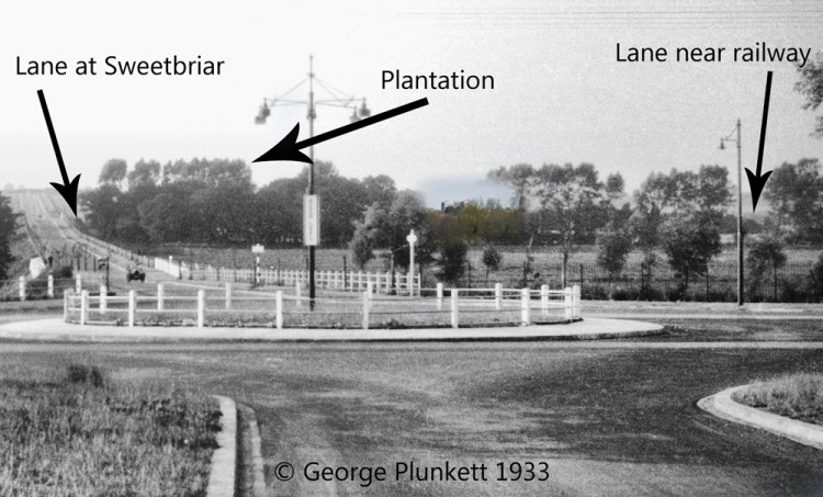
I wasn’t the only person to be taking pictures of Sweetbriar Road across the decades and back in the 1930’s, when the newly-added ring road was being built, a young George Plunkett was also on the scene taking pictures. It’s dawned on me that I’m often following in his footsteps with a camera in hand and using another of his wonderful images, we can see further evidence of our old farmers’ track and its plantation of trees in the background. This image was taken from the foot of the hill at Guardian Road, looking back at Mile Cross across the newly-added roundabout that connected the new ring road to the older Dereham Road. Again, I’ve put in some more ‘subtle’ arrows to show you what you are looking at in the background. I’ve also added in the tower blocks of the 1960’s as a cheeky reminder to how it looks now:
If you were to follow the old lane under Sweetbriar Road and back out across the Marshes again, you would eventually catch up with where the Railway Line crossed the old farmer’s track for the second time. Again, I erred on the side of the caution and took the less scenic route, back up Sweetbriar Road and back down the bank at the former railway bridge, before heading west to catch up with the old farm track where it was interrupted by the railway for a second time. In the following image we can see the old farmers’ track where it disappeared under the later railway, and if you look across the old railway fence you can just about make out the remains of the old lane and it’s row of trees heading east towards Sweetbriar Road.
It’s at this point that the old track disappears under the Marriott’s Way once more, and then behind the multiple security fences of Briar Chemicals, before angling off North and up the side of the valley towards the other Gowing farm at Hellesdon New Hall, now the site of the Hellesdon Barns garden centre. If you peer through the fence, you can make out the old track as it disappears north and into the undergrowth. This is also the point at which another occupational crossing was put in by the railway company for the benefit of the farmers working the land here.
Whilst at Hellesdon Barns at the weekend, I decided to see if I could see anything of the old track as it ran into the former farm and just behind the remaining barn there is a break in the old farm wall, showing us where the track ran up along side it, behind some newer homes.
Whilst wandering around Hellesdon Barns with my family, my attention was drawn to what was still here that tied the former Gowing Farm to it’s landscape. I found quite a few interesting nods to the past that also tied in nicely with what I’d previously written about the Gowing Farm at Old Farm Lane, situated at the opposite end of this former, farm track connecting the two previous farms.
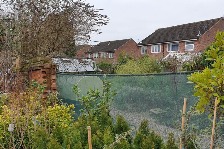
As mentioned previously, unlike at Old Farm Lane, the old Victorian farm house here at the old Gowing Farm is still standing, although seemingly abandoned. It looks as though with a bit of hard work could still make for a lovely home with a fascinating back-story. It’s a building I’d really like to get a better look at to see if there are any more nods to the farmers of years gone by. Whilst I stood admiring this lovely old building and once again wondering about the past, it was something very much alive and very much still in the present that caught my eye.
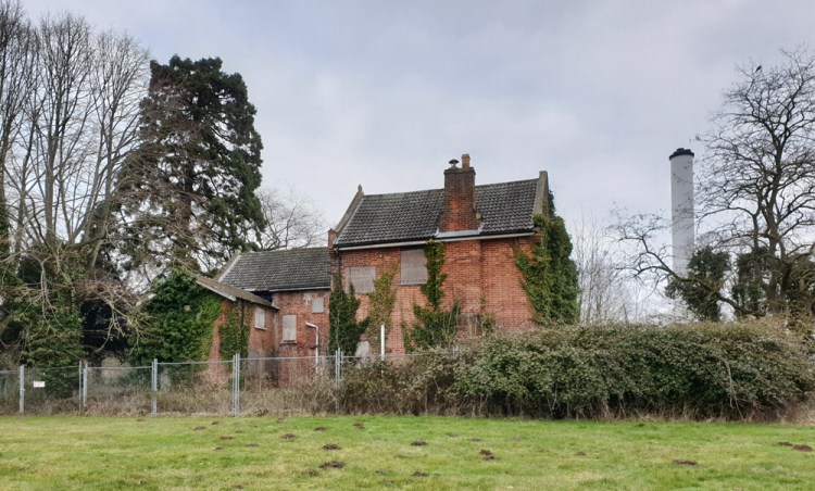
Mostly hidden from view from the road by a collection of mature Fir Trees (most-likely planted at the same time) and some tall, but later deciduous trees is another towering Giant Redwood Tree, standing about the same height as the pair surviving at Hellesdon Old Hall, Old Farm Lane (now Lidl).
I never cease to be surprised at how these little (sometimes massive) clues continue to reveal themselves when you scratch away at the surface of our local history and how connected they all tend to become, the more you delve down beneath the surface.
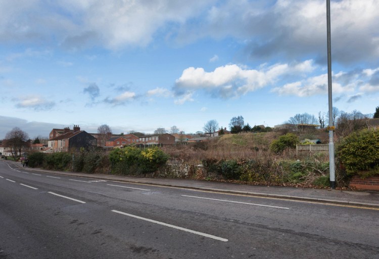
Going back to the old maps and what they tell us about the landscape beneath our feet, other than all of the points mentioned above, there are even more interesting little details to be observed where we can still make out the past in the landscape today. Take the steep banks behind the houses at Fenn Crescent where the houses have been built in the remnants of a former, circular-shaped earth-working. This scar on the side of the valley is one of many that could be found along the course of Drayton Road as it heads away from the city along the northern side of the Wensum Valley. There’s an even bigger bite out of the landscape opposite Wensum Park, which was the site of the Chalk Hill Farm lime kilns and chalk workings. Half of the site disappeared under houses a few years back, but the western half of the land still seems to defeat the most optimistic of house-builders due to its many hidden pits and tunnels. The steep drop on the southern side of the Aylsham Road (as can be seen in the image below) proves how extensive the works had been here in the past.
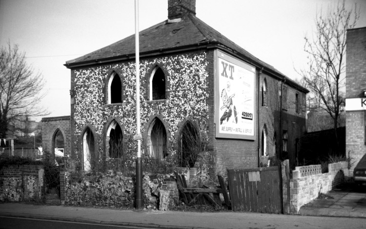
The image below shows the site 1993. All that really remained from it’s past was the Cottage that housed the owners of the lime kilns and chalk workings. The flint frontage to this once-beautiful gothic cottage was most likely extracted from the nearby chalk. It’s a shame that this building was demolished, seeing as nothing has been built to replace it.
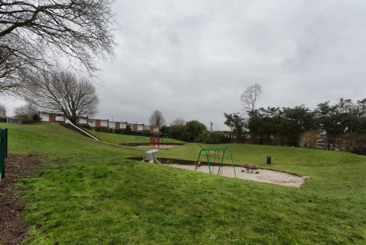
Further earth works can be seen (on the maps at least) at Red Cottage Close, where the first row of homes drop away steeply towards the allotments and are built on another semi-circular cut into the side of the valley. To the north of this earth-work and on the opposite side of the road were three more dents in the ground. Two of them behind the homes on Bowers Avenue, now underneath the Whiffler Industrial estate and a third that can still be seen today, next to Boundary Road. This large hole in the the ground eventually filled with water and was to become the infamous Fungi’s pit. The water has since been drained away and the hole is now the home to a recently updated play park at Bowers Avenue.
Another interesting detail that I spotted on one particular map, which showed up pools of water (ponds and dykes) in blue, were two other fairly-sizeable ponds here on the estate. One at the junction of Aylsham Road and what is now Half Mile Lane and another at the boundary where the Holt and Cromer Roads originally split about 20 meters before they do now and right in front of what would become the Boundary Pub. I did read somewhere that somebody remembered this particular pond being home to some ducks and that the a lady in one of the cottages that looked over the pond (now the restaurant marooned in the middle of countless lanes of traffic) used to hire out bicycles. It’s quite hard for me to picture that scene now, with cars, trucks and vans thundering through the middle of it all. Not so long ago it was a very rural scene with a handful of houses, the final outpost on the very distant edges of the city outside its walls, well over a mile away to the south. Again it should serve as another warning as to what will happen to the remaining green bits hemmed in by the NDR.
Whilst on the subject of the Boundary, the land directly to the west of it was the site of extensive brick fields, taking advantage of the exposed layers of brick-earth up here right at the top of the valley. The Brick fields covered the land along Mile Cross Lane all the way to what is now Weston Road and back to Aylsham Road as far as what is now Woodcock Road.
I mentioned earlier that a certain Matt Williams had produced two images of Mile Cross, helping to show us what is going on beneath our feet and our homes and this is the perfect point at which to see the second. This rough geological cut-through provides us with a great visual representation that ties in nicely with the earth-workings mentioned above and when I say rough, I meant Matt. He insisted upon me stressing to you that it isn’t meant to be one-hundred percent accurate, he created it only as basic visual guide. He’s very meticulous about such things.
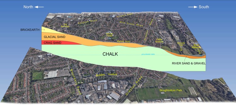
The cut-through image looks across the estate from the west and we can see the land sloping down southwards towards the river. At the top and to the north is the layer of brickearth up at the boundary and under Catton where the sprawling brick works once lived. It’s this brickearth that was used to form the bricks to build the houses here on Mile Cross. As the land slopes away south and down the side of the valley, we can see that the bulk of the original estate is built upon the glacial sands which were deposited here when the glaciers last retreated across this landscape. Underneath these sands is the deep layer of chalk on which the whole of the city stands and as the land slopes towards the bottom of the valley, a ridge of this chalk has been exposed over the years by the eroding power of the Wensum as it snakes its way across the land over millennia.
It’s at this point where all the earth-workings that were dug into the land all those years ago to take advantage of all the free chalk, and why the extensive chalk-workings opposite Wensum Park still stand mostly unbuilt on. The houses that are built on the more stable ground on the eastern edges of the site are again named as a reminder to the past here: Lime Kiln Mews.
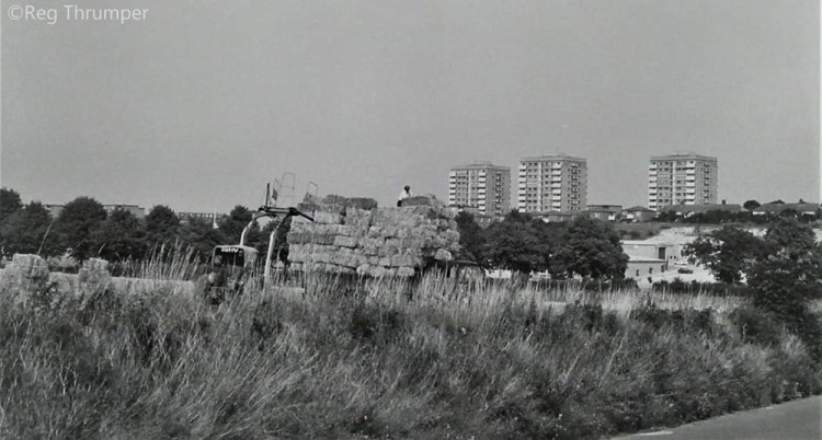
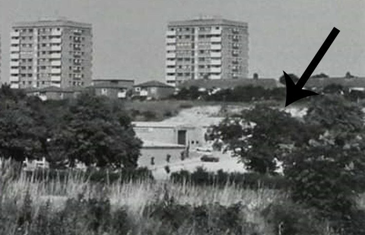
There was another large, visual clue to all of this chalk and it could be spotted behind the factories and workshops at the Whiffler Industrial estate. When the land here was made flat so that these industrial units could be built, the ridge of chalk was exposed close to the back gardens of the now-demolished and replaced houses along Bowers Avenue. I remember playing in amongst it all as a kid during the 1980’s. We’d clamber down from the wasteland where the concrete block houses once stood and dig tunnels that were probably very unsafe and shout childish insults at the people working in the units below, before running off. We used to refer to this area of steep, exposed chalk as “the cliffs” because to us at the time they resembled the white cliffs of Dover. Sort of. You could also spot these ‘cliffs’ quite easily from Whiffler Road. As the years have passed these the bright chalk has since been dulled by weathering and hidden by foliage, and when I went for a look the other day, they were no longer obvious. The old maps show that there was an earth-works here too, long before the Industrial and Housing Estates. Using a crop of one of the images from above, taken from Hellesdon Hall Road in the 1970’s, the bright white chalk can just about be made out behind a unit on Whiffler Road.
Before a wind this piece up, there is another tool available to us that enables us to look at the land beneath our feet from a slightly different perspective. The Norfolk Heritage Explorer is an interactive map that can be used to see all of the notable archaeological finds under Norfolk, including the land under our feet here on the estate, which can help to further build up a picture of the past, a few of which I’ll mention below.
NHER Number 549. A Roman Coin – a late 3rd century Alexandrian tetradrachm – was dug up in a garden at Appleyard Crescent in 1949.
NHER Number 484. Fragments of a Bronze Age Pot, an Allover Corded Beaker, were dug up when a resident was digging a hole for a compost heap at 121 Rye Avenue in 1948.
NHER Number 53979. A late Neolithic flake was found in a garden at 20 Kirkpatrick Road in 2009.
NHER Number 848. Prehistoric worked flints including a Mesolithic or Neolithic burin (a tool used to engrave) were found in the field I used to play in between Drayton Road and Hellesdon Hall Road, the triangle of land to appear in the first map at the very top of this piece. These were found in 1990.
NHER Number 870. A Medieval Silver Penny from the reign of King Edward I was found by chance by somebody walking through Sloughbottom Park in 1991.
NHER Number 366. The site of a pair of Bronze Age ring ditches were at identified at Sweetbriar along with Bronze Age Cremations and fragments of pottery scattered across a wide area. There were also fragments of Iron Age Pottery in the tops of the ditches and a possible trackway, not too far from the more recent farmers track I was discussing earlier. Barrow Close is a nod to the history of the site that Sweetbriar Industrial Estate was built upon.
NHER Number 55598. An early Neolithic flint blade and a prehistoric flint flake were found in 2007 by a gardener working his allotment off Valpy Avenue, the also happens to be the site of our very own Mile Cross Community Allotmnt, or ‘The Common Plot’. I might just pay a bit more attention when I’m digging down there from now on!
NHER Number 696. Again at the allotments, a hammered penny of Edward I, II or III from the Canterbury mint was found in 1982 by a lucky gardener.
NHER Number 411. An inhumation Cemetery containing at least nine bodies, in shallow chalk graves was found between 1960 and 1978 under what are now numbers 5 and 7 at the base of Galley Hill. Burial dates unknown.
NHER Numbers 811 and 798. A palaeolithic flint Levallois blade (1988) and another Prehistoric flint flake (1987) were found by separate walkers in the field in Sloughbottom where the BMX track now sits.
These finds help to paint a picture of the landscape beneath our feet that isn’t just a collection of trees and farmland divided by hedgerows and lanes, but land that has been inhabited by humans and early humans for thousands (if not millions) of years in one way or another. It’s also telling us that we are just the latest chapter to the landscape we inhabit. We’ll soon be just another part of the long and winding history here and I just hope that we won’t damage it beyond repair for the future generations of people and animals who should be able to make up those future chapters, long after us. Those old Oak Trees that I’ve talked about throughout this piece, have been living on this landscape for a few hundred years now and I wonder what they will bear witness to over the next few hundred years. We should feel lucky that we’ve had the chance to share it with them and I for one will look at them in a different way from now on. I just wish that these ancient, living reminders to the past, and the future, could somehow share with us what they’ve seen over time. And on that final, rambling paragraph I shall call it a day.
Thanks once again for reading.
Stu

Another well researched piece about our local history, well done!
LikeLiked by 1 person
What a fascinating story, so much enjoyed and so much more learned. Thank you so much for all the hard work and research you must have done to bring about this informative story to share.
LikeLiked by 1 person
Thank you for sharing all of this. It is fascinating
LikeLiked by 1 person
A fascinating story of how trees bear silent witness to the changes around them. We can only hope that they are protected as the city seems to be undergoing a further wave of expansion.
LikeLike
Dear Stuart,
That was a great post today.
My wife, Sue, and I edit the Norfolk Gardens Trust Magazine (https://www.norfolkgt.org.uk/publications/ ) and we both thought it fascinating how you describe trees (if not chopped down) as markers of urban development. Their preservation becomes more important as the speed of Norwich’s outward expansion seems to be growing fast.
Our members are used to articles on the designed landscape, usually in parkland of big houses, but what fascinated us about your post was that your series of maps show a different kind of development: how trees should be retained and valued in an urban environment.
We would like to invite you to write a short piece (900 words plus six/seven photos) for the autumn edition of the magazine? The deadline would be September the 18th so it’s a long way off.
You could choose more or less any angle you like: trees in an urban landscape; trees and the history of the Mile Cross Estate etc etc.
I do hope you’ll agree – please let me know if you’d like to bounce ideas around.
All best wishes,
Clive
>
LikeLiked by 1 person
Hi Clive, I’d love to. Stu
LikeLike
That was fascinating, thank you. 🙂
LikeLiked by 1 person
Great research and a very unusual perspective for local interest / history. A wise old oak tree is a very underestimated resource for discussing problems and seeking advice. Think of all that experience and mental health support that is available!
LikeLike
With reference to the trees planting behind the boundary pub I wonder if there’s any coincidence with the trees (curvature) planted on the catton grove road/mile cross lane traffic light junction.I also wondered what is the history of the terraced cottages running from the junction of Middletons lane up Drayton high road towards Asda? Have found your historic research fascinating
LikeLiked by 1 person
Hi James, the trees you refer to are London Planes and are only (I say only) about 100 years old and I suspect they were planted by Sandys-Winsch in the late 20’s/early 30’s. As for the row of terraces, I often driven past and wondered. I always assumed they were worker’s houses for the Hospital, but they don’t start to appear until about 1905, much later than the Hospital. They could still be worker’s houses for the Hospital, or the plantation/nursery on which they were built.
Regards,
Stuart
LikeLike
Your piece was absolutely riveting! I live on the Low Road in Hellesdon and remember the fields in the 1970’s before the enormous building in of green spaces.
My house has 39 concrete tank traps from WW2 and I am interested in discovering more. Have you looked at the sadly destroyed Royal Golf Course and it’s environs? Everywhere is being built on and the loss of green is most distressing.
Thank you for the great writing and research.
LikeLiked by 1 person
Hi Victoria, I have been over the golf course recently to capture it on camera before it’s all gone. There’s some impressive tank traps at Gunton Lane, but you wouldn’t be able to relocate those!
Glad you’re enjoying the blog.
Stu
LikeLike
Hi, Stu! I was interested to wee your picture of the, now long gone, Gothic Cottage on Drayton Rd. opposite the top of Wensum Park. I remember it as being lived in and preceded by a Victorian terrace, run-down but still inhabited. Have you any ideas about the large 5-bay Georgian house set behind, demolished in the 70s like the rest of that wedge-shaped area. The gardens further up before you hit the extension of St. Martin’s Rd belonged to it, I think. And the sawmill, perhaps? The Gothic Cottage may have been its lodge originally, though it may have had a frontage on Aylsham Rd. as well. It had the same sort of feel as the Ivory-designed houses on Surrey St- my mother and her sister had a flat in one of them just after the War- very plain, grey brick and the only ornament was a pair of Grecian quadrant-shaped knobbly bits at the two corners you could see, rather like Soane. Did George Plunkett ever photograph it? I must have gone past countless times on the ‘bus over the years.
PS. I think the V2 crater you mention is a couple of hundred yards from the Middleton’s Lane crossroads on land belonging to the old Golf Club. Still unbuilt on, I believe. Too deep for a a digging for chalk or flint I remember sledging there as a kid. Much nearer to us than St. James’ Hill!
LikeLike
Hi Michael, I’m not sure about the demolished house, the area of its gardens is now known as Clapham Wood. I did write a piece about the tall houses nearby on Aylsham Road here: https://themilecrossman.com/2020/08/11/aylsham-road-a-window-into-the-lives-of-a-mile-cross-family-in-the-early-1900s/
Plunkett didn’t capture much around this location, which is a shame. There is a Swain photograph of point house where Aylsham Road and Drayton Road meet on Picture Norfolk: https://norfolk.spydus.co.uk/cgi-bin/spydus.exe/FULL/WPAC/BIBENQ/200875967/2218293,9
I think the bomb crater has finally been built upon.
Kind regards, Stu
LikeLike