With the 100th anniversary for the first ever council-built homes appearing in Norwich approaching quickly, along with the fact that I’ve been contacted by various people from the City Council to the national and local press to offer up my opinions, I thought I’d better type something up about this interesting and important anniversary and take a look back over the last century of social housing right here in Norwich. Before I start proper I’d better mention that some of this info has been taken from (and in some cases corrected) the centenary section on the City Council’s website, which I’ve sorted into a crude chronological order, added to, and worded in my own way; a lot of which I’ve also already written about previously during the last three years of this blog.
As I’ve touched upon – frequently – before; by the end of the First World War in 1918 there was a huge demand for housing in the cities and towns throughout Britain, the problem becoming so large that it was now an unavoidable one for the British Government. By 1919, Parliament had passed an ambitious Housing Act, or the creatively-named: “The 1919 Act” (also known as the ‘Addison Act’) which promised generous subsidies to help finance the construction of up to 500,000 houses within a three-year timescale.
Unfortunately, these well-intended plans were being drawn up at the exact same time as the economy taking a turn for the worse. Economic output fell by 25% between 1918 and 1921, meaning (inevitably) that funding had to be cut, which in turn meant that only 213,000 (less than half) of the planned homes were completed nationally under the Act’s provisions. As a consequence, the much-vaunted ‘Homes for Heroes’ were not being built as quickly as promised. Thankfully, Norwich was one of the places that was to benefit from the building of some of these new homes:
The 1920’s:
The first official council houses to appear in Norwich were built on a new development straddling the end of Angel Road in October 1920. The development consisted of a small collection of houses erected on a triangle of land, formerly allotments just South of Philadelphia Lane and on a slightly larger piece of land the other side of the road to the south of Elm Grove Lane, on the site of a former rectory (and more allotments).
Houses on Collins Court over looking a green, close to the former rectory:

Seeing as these were still very much fiscal times, some of the bricks used to build these new houses were recycled from the now-defunct windmill and its supporting buildings at Press Lane, just to the west in Upper Hellesdon (Mile Cross). The windmill tower had been standing, unused after it had been ravaged by fire back in 1913.
Homes on the other side of Angel Road, note the reversal of the same design above:
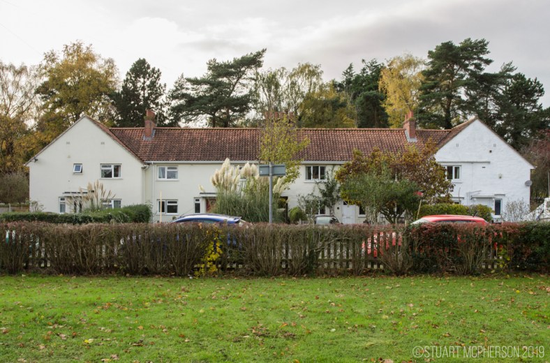
As you can see above, the style of these pleasant-looking, early Angel Road houses are not too dissimilar to some of the homes that preceded them, particularly in some parts of Mile Cross and they were built with plenty of space and generous gardens, a far cry from the Victorian terraces and the Yards that were prevalent throughout Norwich at the turn of the century and some of the modern homes being built today.
By 1923 the restrictive post-war labour and material shortages were beginning to ease and this allowed for the much-needed construction work to pick up again. Extra funds were also freed up to buy up additional land – on top of the land already-purchased land at Mile Cross – in Lakenham in anticipation for the building of more new housing to the south of the City.
The building of Mile Cross was now well under way and it was to be the first substantial housing estate built by the council in Norwich. The Norwich Corporation (Norwich City Council) decided to employ the respected town planner, Stanley Adshead, who was a former Professor of Civic Design at the University of Liverpool to create the plans for Mile Cross. He in turn decided to utilize the skills of local architects to come up with a variety of different and modern housing designs for this bold, new estate; one of which being the rather famous George Skipper (of The Royal Arcade fame).
A typical Mile Cross scene from the early 20th Century:
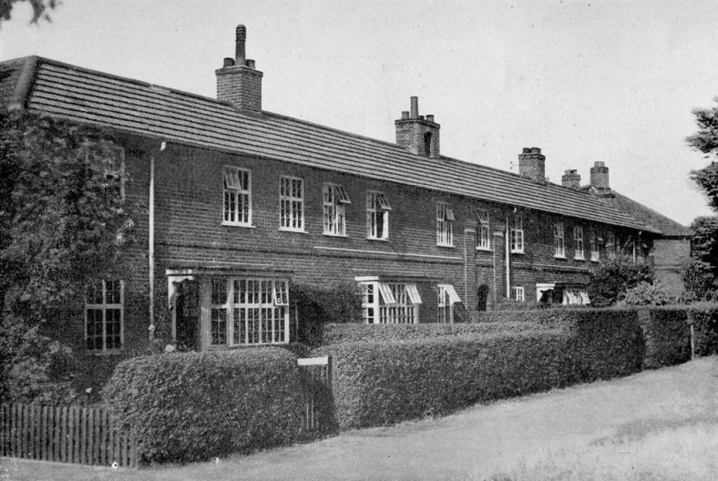
In an odd twist of fate and wordplay, the workforce employed to build the estate was made up of out-of-work soldiers who had recently returned from fighting in the Great War, meaning that ‘homes fit for heroes’ ended up being built by the heroes themselves. By the late 1920’s the original parts of the estate were now complete, although there were to be a few minor additions in the early 1930’s. These came in the form of a slightly different design of house, most of which were built on the allotments and the Half Mile Lane area situated between Drayton Road, Mile Cross Road, Aylsham Road and Junction Road. For a short time this area was actually referred to as the ‘Mill Hill Estate’, a name rarely mentioned these days and now under the general umbrella of ‘Mile Cross’.
As the building of Mile Cross was drawing to a close the housing designs created by the architects for the estate were pretty much copy and pasted onto similar developments that were springing up along the new ‘outer ring road’ as it crept its way around the south of the city, starting at Colman Road and then moving on to Barrett Road/Long John Hill area in Lakenham. The house designs are mostly identical to some of those in Mile Cross and some are of a slightly newer design the further east you get along the new road. Some also bear a resemblance to those original houses on Angel Road. The parade of shops at Colman Road are also of the same design as those at Drayton Road (only laid out in a slightly differently) and the nearby Earlham Library is also pretty much exactly the same as the one on Aylsham Road in Mile Cross; however, the one in Mile Cross was actually built after and was originally designed to be bigger.
The 1930’s:
By 1930 there were around 2,300 eligible people on the housing waiting list and in the 90 years that have passed since then that figure – to my surprise – has (only) doubled to around the 4,000 mark in 2019/2020. Luckily for these people, the home-building ball was now well and truly rolling in Norwich and in 1932 The Lord Mayor, Alderman and citizens of Norwich borrowed a sum of £83,803 from the Ministry of Health for “the provision of working-class dwellings on the Catton Grove Estate and purposes connected therewith”. By 1935, most of these new homes were ready for their first tenants.
To be able to build this new Catton Grove estate, the council needed to complete a compulsory purchase order of land that had been formally used as allotments for the local Asylum and one of the caveats of this sale was that that none of the building work was to be carried out on any Sunday.
Due to massive piles of sand dotted around the building site, particularly on the George Pope Road side of the new estate, the area became known locally as the ‘The Klondike’, a reference to the piles of sand resembling piles of gold and I know at least one Mile Cross ‘old boy’ who still refers to ‘The George Pope’ as ‘The Klondike’ some 80 years later.
One of this new estate’s more famous characters was a Champion boxer going by the name of Ginger Sadd. Ginger lived on Bullard Road and beat many of the top boxers of his era but he only had one attempt at a British title when he fought Jock McAvoy over 15 rounds in May 1939. Ginger came so close, losing on a narrow points decision.
At around this time (1933) The regulations for the Conduct of the Housing Estate stated that tenants should pay the princely sum of nine shillings and four pence weekly rent.
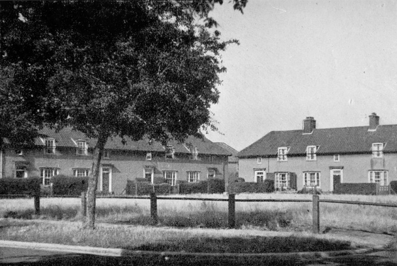
The housing stock continued to grow in Norwich and 1935 was the year in which the City was to see its first council flats. These new-fangled flats began to appear on Union Street and in the following months, the city’s first tenement blocks were also beginning to be built nearby in Barrack Street. Similar buildings were also beginning to appear at St Martins Close, which were being built on the former sites of Sun Yard and Greenland Fishery Yard, just across the river from Norwich City Station. The houses demolished to make way here were noted as being in particularly bad condition and had been declared unfit very early in the city’s slum clearance programme. Also to appear in the mid-1930’s was The council’s Magdalen Close development which was built on the site of a small square of Tudor buildings at the back of the White Lion pub on Magdalen Street.
In 1938 and at about the same time that the new City Hall was opening, the North Earlham, Larkman and Marlpit estates were being developed to the west of Norwich on land that had been gifted to the people of Norwich by the Colman family. Before this new City Hall was built, the Council City Estates Department was responsible for housing and this was located nearby on Gentleman’s Walk. An interesting and rather unfortunate note about the Larkman Estate is that it was quickly given the nickname of ‘Monkey Island’, a derogatory phrase used to describe some of it’s less-financially secure inhabitants; the phrase being coined by female ‘clippies’ (female bus conductors) during the Second World War.
New houses at Larkman:
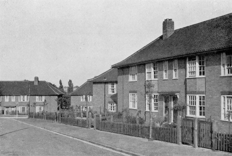
And at Earlham:
The onset of yet another war, and the 1940’s:
By 1939 Norwich City Council had so far managed to build and supply around 7,600 homes in the city and about 44 per cent of these new council homes were built to rehouse those displaced by slum clearances, meaning that over 4,000 additional homes had been built. In comparison, the figure for recently built private housing in the same era was at about the 3,000 mark.
At this point we can see that the supply of new and improved housing was coming along nicely, but the residents of Norwich and its housing stock were about to recieve a rather hefty kick in the nuts with the onset of World War 2. During the course of the war 2,000 Norwich homes were completely destroyed and another 27,000 suffering varying degrees of damage. When you take in to consideration that Norwich only had 35,000 dwellings to begin with you can see what a problem this was going to cause for the city’s residents and the authorities.
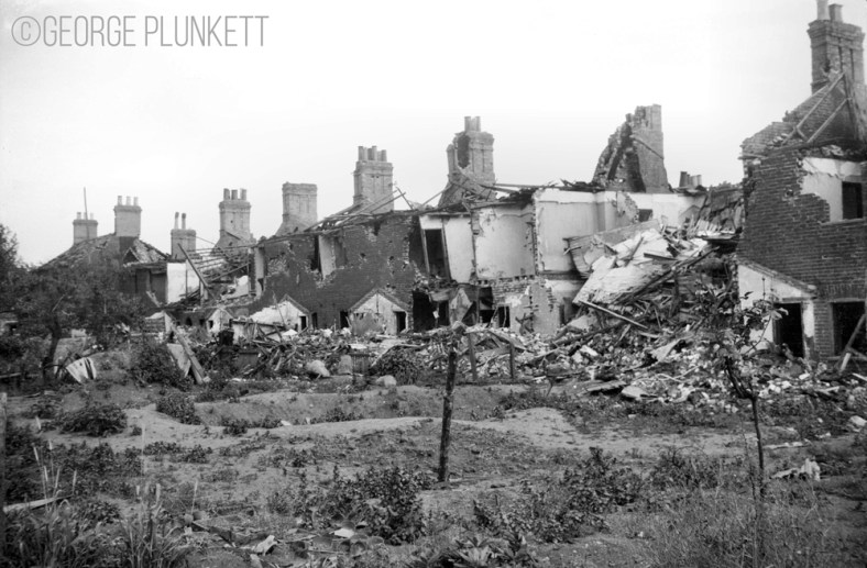
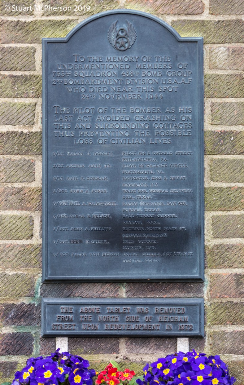
The war also took it’s toll on the people and by the end of the war 320 citizens had been killed by enemy action, on top of that a further 1,092 were injured. Because of the constant threat from enemy bombers almost every home would have had an Anderson shelter which would have cost £7, or provided free of charge for homes bringing in less than £5 a week in wages. On top of this most streets would have had a surface shelter nearby. The threat didn’t just come from the enemy either as the skies above Norwich were also full of allied bombers. There is an interesting memorial a plaque on the Council’s Freeman Square flats commemorating the crew of ‘The Lady Jane’, a USAAF Liberator bomber that had gotten into difficulty on 24 November 1944 after clipping the top of the old St Philips Church tower nearby. The young pilot fought bravely to bring his stricken aircraft down on one of the few open areas without any homes; the corporation railway sidings, narrowly avoiding hundreds of buildings. 2/LT Ralph Dooley’s gallant final act no doubt saving countless lives, a fact not forgotten by the people of Norwich.
Tenants to the North of the City had also become accustomed to countless, low-flying military aircraft buzzing their chimney pots on their way in or out of the new military airbase at Horsham St Faiths, and on one occasion this led to tragedy on the Mile Cross Estate, as covered in this heart-wrenching story from an earlier post: “Dick’s Story“.
The armed forces were quite a common sight for tenants in the north-eastern parts of the city, those living close to Mousehold Heath would often see the area being used as a training ground for the soldiers stationed at the nearby Britannia and Nelson barracks and had become accustomed to the sight of Tanks and APC’s rattling up and down the roads.
Another small but interesting impact of the war was that the council’s house painting programme had to be suspended because factories were now only making paint for military purposes.
Post WW2:
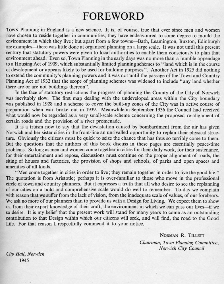
By 1945 the war had finally come to an end, but the City was left to lick the many wounds inflicted upon it by enemy action – and the effects of austerity (sound familiar?) – and a forward-looking plan for the future was needed. The City of Norwich wasted no time here, coming up with the (now infamous) “City of Norwich Plan, 1945”. The ideas proposed within it were bold, with grand concepts for the rebuilding and restructuring of the city and its diminished housing stock. Luckily (or not, depending on your view-point) a lot of these proposals never came to be; however, some of the ideas thought up did make their way from paper to reality, having a profound impact on how parts of the city look to this day, the inner-ring being a prime example.
The post-war vision for the future, City of Norwich Plan, 1945:
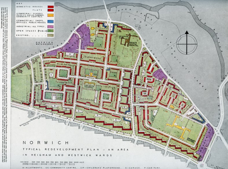
And one of the plan’s proposed redevelopments, this of the Heigham ward:
In the meantime and to help with the immediate shortage of homes, 350 prefabricated houses (or ‘Prefabs’), were built in many open areas, including some of the areas previously flattened by bombs. Mini prefab ‘estates’ began to appear in areas such as at Kett’s Hill, Tuckswood, Angel Road and Junction Road and if like me you love to scour the ‘Britain From Above’ website you’ll see that you can find them dotted about all over the city. These temporary homes were only designed to last a maximum ten years whilst a more permanent solution was sourced.
These prefabs turned out to be very popular with the residents that had moved into them; they were warm, comfortable and equipped with all the mod-cons. Many of the residents living in these supposedly-temporary chalets were so happy with their new homes that some were in no hurry to move out again. The last occupied ‘Prefab’ managing to survive right up until 1976!
Prefabs on Kett’s Hill:
![Kett's Hill post-war prefab homes [4707] 1962-09-01](https://themilecrossman.com/wp-content/uploads/2019/07/ketts-hill-post-war-prefab-homes-4707-1962-09-01.jpg?w=788)
In 1946, the pre-war trend of building new houses had come back to life and work began on the building of the West Earlham and Tuckswood estates. Around 150 of these new houses to be built were the new British Iron and Steel Federation (BISF) houses, which were relatively cheap and easy to erect, just what the Council needed to help ease the burden of the post-war housing shortage. The Tuckswood Estate was built on land that was formerly the sprawling grounds for the recently-demolished Harford Hall, which is presumably where Hall road gets its name from.
The 1950’s:
By 1950, Norwich City Council had now built almost 1,500 permanent new homes. Some of which were Ministry of Fuel and Power-sponsored homes in West Earlham, these were seen as state-of-the-art for their time with special insulation and ‘whole-house’ (central) heating and by 1952 Norwich was ranked fifth out of all the county boroughs in the country for the number of permanent homes to be built or rebuilt.
To further aid this mini housing-boom the post-war restrictions on building finally come to an end in 1954 and Norwich Council set about the construction of yet another new housing estate, this time at Heartsease. The estate was to be built on the wide, open site of RAF Mousehold Heath, a now-disused First World War airfield.
At around the same time another estate was also being built at the bottom of Sandy Lane in Old Lakenham on a wedge of land situated between the rivers Yare and Tas and the two of the busy Railway lines coming out of Thorpe Station.
In 1955 the architect David Percival was appointed by the city to help with housing and his aim was, “not only to reflect the regional architectural tradition in housing schemes but to give individual character to each site”. Basically, he was bored of the repetitive nature of the post-war housing created so far and wanted to mix things up a little by trying to be bold and to break up the previous, monotonous design templates. His modern (for the time) designs mixed multiple styles of homes and trying to incorporate building materials and colours that reflected and complimented their surroundings. You can see a lot of his inspiration around the fringes of the city, particularly in the areas of Vauxhall and Heigham.
In 1956 there was a ceremony held near Mousehold Heath to mark the opening of the 6,000th post war council home to be built in Norwich.
It seems that attitudes to traditional-style housing were beginning to evolve with the times and a survey of waiting list applicants conducted in 1957 showed that 60% of them would be willing to live in flats close to the city centre.
In 1958 Norwich City Council decided to move their entire labour force to a brand new and centralised depot situated close to the river in the southern portion Mile Cross. The “Norwich City Works Department” officially opening in 1965. You can read up on the history of that site by clicking on this link.
In 1959 Norwich City Council won the ‘Good Design in Housing’ award from the Ministry of Housing and Local Government, for the building of Alderson Place in Finkelgate. At about the same time the Council set about redeveloping the Philadelphia Lane area which lead to the division of the road into two new roads; Penn Grove and Sleaford Green.
The 1960’s:
As the city embraced the 1960’s it also embraced the idea of the Tower Block, the first of which to rise up being the Eleven-storey Compass Tower at Heartsease. This tower was shortly followed by two more nearby, the three towers in Mile Cross and the Normandie and Winchester Towers situated closer to the city centre. These two towers are the tallest in the Council’s housing stock at 16 storeys. In all eight tower blocks were built across Norwich and thankfully no more followed. By the mid 1970s Norwich City Council had introduced a policy stating that buildings must not be built above four stories high under the guidance of Patricia Hollis, better known as the Baroness Hollis of Heigham.
This is the reason Norwich has kept a relatively low skyline and, unlike many cities, only has a small number of high rise flats, although this could be set to change if the ghastly-looking tower at the Anglia Square site is given the go ahead. If it does I fear a new precedent might be set, putting our City’s iconic skyline at risk.
The 1970’s:
New homes were beginning to appear everywhere and by the 1970’s Norwich could proudly claim to have the highest proportion of council housing of any city in the entire country.
In 1970 thirteen new flats were built around a central green at Pottergate/Cow Hill and these were designed by Tony Whitwood of the City Architects’ Department.
Also in the 1970’s the former Barnards Foundry on Coslany street was demolished to make way for houses and flats. An unusual feature noted by George Plunkett regarding Coslany Street was that it had iron kerbs running along either side which had been laid to protect the edges of the pavements from the excessive wear and tear, which would have been caused by heavy iron-tyred horse-drawn vehicles constantly entering and leaving the Iron works. To retain the site’s industrial history the council named the new development “Barnard’s Yard”. A part of this development famously featured on an album cover for the band “Killing Joke”.
In 1974 construction began on the site of the long-deserted, medieval village named Bowthorpe. Originally, it was designed to be a collection of three modern villages and the idea was to encourage a sense of community but this idea was never properly followed through. This build was something a little different and wasn’t completely a ‘council estate’ as such. This new development incorporated a mixture of private, social and sheltered housing. The estate was expanded on with the additions of Clover Hill and Chapel Break in 1982. The last homes built by Norwich City Council in the area were at ‘Tippett’ Close and ‘The Runnell’ in 1990.
An interesting little snippet of history regarding Bowthorpe is that in 1549, Robert Kett briefly camped on the site of the Bowthorpe estate during the early days of the ill-fated rebellion that was to bear his name. In July 1549, the Sheriff of Norfolk, a Sir Edward Wyndham, was almost pulled from his horse by the rebels in the village as he tried his best to dissuade them from continuing their revolt. Kett and his men quickly decided that the area was too exposed for a rebel camp, moving on to their camp at what is now Kett’s heights on Mousehold Heath, overlooking the City. Kett and his men made their way north around the city, crossing the Wensum at the site of the Hellesdon Road Bridge, close to where the Marlpit estate now lives.
In 1976 the Heathgate estate was built on the site of the old Horse Barracks. The barracks could be dated back to 1791 on the site of Hassett House, later known as the Cavalry and Nelson Barracks. These large barracks were capable of accommodating as many as 320 men and 266 horses, but in 1963 it was deemed that they were no-longer needed by the military and were demolished to make way for more new homes. The street names ‘Cavalry Ride’ and ‘Hassett Close’ are a nod back to the area’s former military history.
In 1978, 43.2% of Norwich City Council’s four bed houses and 48.4% of five bedroom houses were in located in North Earlham. In the same year North Earlham estate was also the first pre-war estate to benefit from the concrete front garden paths and common passageways programme.
The 1980’s:
In 1981 the ‘Right to Buy’ scheme was introduced by central government, giving council tenants the right to purchase their home at a discounted price and in the first two years of the scheme, 1,000 Norwich tenants bought their homes. The plan was to use any money raised from the sale of a property to replace them with new council homes but the plan has never been properly managed, leading to a slow but steady decline in the numbers of properties at the council’s disposal. That’s not to say that no new homes were being built and in 1986 more homes in the Mousehold Heath area are built (although I’m not entirely sure which homes the Council are referring to here).
During the 1980’s the Mile Cross Estate was witness to a large-scale modernisation project in which bathrooms and kitchens were given some much-needed improvements. During this modernisation period most of the homes with tiny extensions that housed the toilet had this part demolished and the toilet mived within the new -slightly smaller- footprint of the house and having a new entrance to the toilet and bathroom put in so that neither were accessed directly from the kitchen.
The 1990’s:
By the 1990’s the council’s role as landlord changed from ‘building’ homes to ‘enabling’, working in partnership with housing associations to supply new homes and working registered social landlords. It also appears that in some areas chunks of the city’s housing stock were passed over to the care of certain housing associations.
In a 1990’s nod to the past, some tenants of the Pilling Park estate were temporarily re-homed in wooden chalets close to the park whilst their permanent homes were being underpinned. These modern ‘prefabs’, like their distant cousins – the post-war prefabs – proved to be very popular with the tenants and some stated that they would rather stay where they were, as opposed to moving back into their permanent homes.
In 1992 Sheltered housing was being built by the council at Fellowes Close and Singer Court.
The 21st Century:
In 2006 the council decided it was time to start embracing the digital age, launching a pioneering new website which was designed to help tenants to find suitable properties online if they were looking to swap their home with someone else. This website aimed to make completing ‘mutual exchanges’ easier and the website is still in use today.
In the same year the Decent Homes standard is introduced by central government.
The current tenancy agreement was introduced in 2010. which is a far cry from the older tenancy handbooks provided in the past, where tenants were given advice on how to keep a fireplace clean, how to store fresh food, use taps, clean windows, guidance for suitable sizes of sheds and how to grow their own vegetables.


Some of the adverts did leave a little to be desired though:
There is a section from one of the older tenants handbooks that I feel should probably be re-emphasised though and that is the guidelines on how to look after and report damage to the estate’s green spaces and verges. Currently the verges and greens dotted about the estates are in a real mess due to an increased desire to own and park multiple motor vehicles and I had a bit of a rant about it all in this previous entry.
In 2012 the ‘Norwich Standard’ was introduced by the council and its aim was to go above and beyond the requirements listed in the government’s previous ‘Decent Homes Standard’. By 2019, 99% of the homes had achieved this newer standard.
2016
New Council houses were built at Riley Close in the Heartsease on a large plot of land formerly taken up by a pub named ‘The Canary’ and its large car park.
2017
At Hansard Close off Mile Cross Road, the former Mile Cross Area Housing Office is demolished to make way for modern Passivhaus properties.
Hansard Close, before:

After:

Also in 2017 the former council offices on Bullard Road were transformed into six new homes and one of these houses the council tried something a little different; a complete modular kitchen which had been built entirely off-site before being attached to the property.
2019:
In 2019 The Council’s much-vaunted (and somewhat controversial) Goldsmith Street housing project was completed, providing 93 new homes to a Passivhaus standard. This development was the first social housing development to be awarded the RIBA Stirling prize and has been on the receiving end of much media interest ever since. The area is currently being used to try a inspire similar projects across the land.

Below is a list of interesting little bite-sized facts, lifted from Norwich City Council website regarding their Council homes:
- Norwich City currently has over 14,500 properties making it the biggest local authority landlord with housing in England (2018), excluding metropolitan districts, unitary authorities and London boroughs. Alongside renting houses, the council owns around 3,400 garages and parking bays that are dotted around housing estates and the city centre.
- 60% of current tenancies are held by a female and 40% by a male. Five of the Council’s tenants are over 100 years old!
- Norwich council properties are between 50 and 100% cheaper to rent than equivalent properties in the private sector. What this really means is that the rents in the private sector are way over-priced.
- The Norwich in Bloom competition attracts a lot of interest each year. In 2002 the tenants of Brook Place won the community category and were presented with a trophy by the Lord Mayor and Lady Mayoress. During the 1990’s My mother and father religiously took part in this competition, even renting a nearby allotment to help grow their floral displays.
- In the 2018-19 the Council helped 85% of households where there was a potential risk of homelessness were from becoming homeless.
- A number of the Council’s latest homes at Hansard Close, Rayne Park and Goldsmith Street are built to ‘Passivhaus standards’. These are highly eco-efficient designs, which reduce fuel costs by up to 70%.
- 49% of city council’s homes are one and two bedroom flats and 42% are houses (majority three bedroom). The remainder are maisonettes and bungalows.
- The city council currently manages 26 sheltered housing schemes across the city, providing around 1,000 homes for older people.
- The tenant and leaseholder magazine has been published for many years and in 2002, following a competition, it was renamed to ‘Tenant Talk’ and then in 2010 it became ‘TLC’. The magazine is currently published three times a year.
- Home Options, the way to register for social housing in Norwich, Broadland and South Norfolk was launched in November 2007.
- Most tenants have a secure tenancy, which offers the best level of protection, reassurance and rights compared to other rented properties.
- To celebrate 100 years of council housing, the council will be planting 100 trees across the city in and around areas with lots of council homes. These will be planted between November 2019 and March 2020. Each tree has been specifically chosen for the location.
The future:
As I write this, Norwich City Council have just announced that – bouyed by their successful Goldsmith Street project – intend to keep the ball rolling by building a further 500 homes by the year 2026. They currently have a budget of GBP100,000,000 to spend, although that will also need to include maintenance on 17,788 homes and 3,333 rented garages.
The city’s eight tower blocks are also under review and it is expected that they will need some significant amounts of money spending on them to bring them fully up to date. As with most Tower blocks built in the 1960’s they do require a lot of maintenance. GBP2,000,000 was spent recently to make them even safer as a direct result of the appalling Grenfell fire tragedy. On top of this it is predicted that in the next 10 years a further GBP60,000,000 will need spending on them to upgrade the boilers and replace the windows.
Where all these new homes will built is not clear as of yet, but I wouldn’t be surprised if the recently-cleared Mile Cross Council Depot site is to be utilized as part of these big plans. The 100 year anniversary of the first ‘Council House’ could be celebrated by a long-overdue increase in Council Homes being built and it could also mean a large expansion to the constantly-adapting and ever-lasting Mile Cross Estate, and I think it would be a very fitting way in which to mark a centenary of Council Homes in Norwich.
The TV architect George Clarke has also waded into the housing debate and decided to try to get government to act on the severe lack of Council-owned housing currently being built across the country. His movement is gradually gathering momentum and his Council House Scandal website is definitely worth taking a look at. Here’s hoping, that like Norwich City Council, he see’s some success with this and that we as a country at least start to try and tackle the inescapable problems that we were also suffering with a century ago; a shortage of socially-provided housing, and to challenge the completely bonkers mind-set that living in a property where your landlord is also your local government is somehow something to be looked down upon.
It really isn’t.
Thanks once again for reading,
Stu

Great review of council-house building in Norwich. Congratulations Stu.
LikeLiked by 1 person
I was born at 25 Cadge Rd North Earlham in August 1929. My mum and Dad had moved there in about 1927. When I was a young boy in the early 30’s there was no Larkman Estate and Cadge Road finished at Wrench Road. Work on the extension of Cadge Rd. to Dereham Rd began around 1934 – 5. I can remember Jex Rd. Estate and the Ritz Cinema being built just before 1939.
LikeLiked by 1 person
I think the 80,s buildings near Mousehold, were the ones that replaced the older properties in the area of Harcourt close off Silver Rd.
LikeLike
The “prefabs” on Woodrow Pilling Park were built In the late 1980”s, to decant people whose houses were falling into the gravel pits of the area. These were rafted and tenants moved back in, not always to the same house!
There was also an issue were people had exercised their right to buy and their houses were at risk, one such pulled several others into the hole too!
The prefabs fell into disrepair, became something of a community resource and finally were demolished in the 90’s.
Because they were used, in the end as temporary accommodation, there was an issue at the local schools where different languages were heard- this was something new for Norwich, not so much now.
LikeLike
I left Norwich to live and work in the Paris suburbs in 1980. I can compare policies in France where a balance of private and housing association type has been respected.Norwich still appears exemplary but I was wondering if the potential destruction since “right to buy” had spoilt the healthy availability of local authority accommodation.I learnt a lot from your excellent article.
LikeLiked by 1 person
My grandmother, Mabel Lamb, lived at council flat 32 Magdalen Close during the 1960s and 1970s. I stayed with her in 1964. I have been researching information about my grandmother and about 32 Magdalen Close then and now. My grandmother, Mabel Lamb, passed away in 1989. If anyone has information about my grandmother and 32 Magdalen Close back in 1964 and now, I would love to know about it. I currently live in Carmel, California USA. My email address is:
fjshaw1@yahoo.com from Frances Shaw
LikeLike